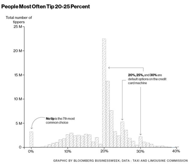
• Membership
  • Newsletter
  • Projects
  • Learning
  • About
  • Member Login
  • Last day to pre-order a song chart poster

    September 18, 2014

    Topic

    Site News

    Chart-topping songsToday is the last day to pre-order a song chart poster. Now is the best time to get it, since after this it’s probably going to cost like a billion times more. Bonus: It’s also a great way to support FlowingData.

    Thanks to all those who ordered already. I’m expecting to ship late October.

    Pre-order your poster today.

    P.S. There’s discounted shipping when you order more than one or order it along with the famous movie quotes poster.

  • PhD gender gaps around the world

    September 18, 2014

    Topic

    Statistical Visualization  /  gender, Periscopic, PhD, Scientific American

    Periscopic, for Scientific American, visualized the number of PhDs awarded in various countries. You might expect men to be in high percentages and women to be in low, but it’s not always in that direction.

    In the U.S., women are going to college and majoring in science and engineering fields in increasing numbers, yet here and around the world they remain underrepresented in the workforce. Comparative figures are hard to come by, but a disparity shows up in the number of Ph.D.s awarded to women and men. The chart here, assembled from data collected by the National Science Foundation, traces the gender gap at the doctoral level for 56 nations. The situation in individual countries varies widely, but as the numbers make clear, there are interesting exceptions to the global trend.

    Each view shows a vertical dotted line to indicate where PhDs awarded are an even split between men and women. To the left of that dotted line shows where men earn more PhDs than women, and on the right, where women earn more than men.

  • Search for word usage in movies and television over time

    September 17, 2014

    Topic

    Statistical Visualization  /  Bookworm, movies, television

    Movies and television shows often reflect cultural trends of the time they are made in. Even movies that take place during the past or future can say something about the present through metadata or production style. Benjamin Schmidt, an assistant professor of history at Northeastern University, provides a tool that lets you see trends in movie and television dialogue.
    Read More

  • Powers of Ten, Derek Jeter style

    September 16, 2014

    Topic

    Infographics  /  baseball, Derek Jeter, New York Times

    You’ve likely seen the classic Powers of Ten video from 1977. It starts on an individual and continues to zoom out farther to a view of galaxies. The video provides a sense of scale that makes really big (and really small) numbers more relatable. We’re just not very good at picturing scales beyond a certain range.

    So when you hear that retired baseball player Derek Jeter took an estimated 342,000 swings during his professional career, you get that it’s a lot, but only kind of. The New York Times went all Powers of Ten on the Jeter swing count to help you see better.

    The piece starts with a single swinging Jeter, and as you scroll down you get the average swings per at-bat, then practice swings per game. Keep going, and you get the career total.

    See all the Jeters.

  • Pantone beer cans

    September 16, 2014

    Topic

    Data Art  /  beer, Pantone

    Graphic designer Txaber created beer can labeling to match the typical color of each beverage to its Pantone color.

    Patone beer cans

    I probably wouldn’t buy beer with this labeling though. Usually you look for more complexity in your beverage, and these colored cans say flat and single-noted beer to me. Fun though. And maybe useful for beer beginners. [via Boing Boing]

  • How to be not ignorant about the world

    September 16, 2014

    Topic

    Statistics  /  Gapminder, Hans Rosling, health

    Recurring TED talker Hans Rosling returns with his son and Gapminder Foundation co-founder Ola Rosling and an update on their latest work: the Ignorance Project. They hope to shift people’s biased perception of world progress towards the statistics — and to surpass chimps in correctness.

    The audience quiz and real-time results work perfectly. I’m guessing the audience answers on their keypads, Ola enters the results backstage, and then the audience sees the finished slide by the time Hans gets there.

  • Probabilities of failing birth control methods

    September 15, 2014

    Topic

    Statistical Visualization  /  birth control, New York Times

    In high school health class, where I learned about contraceptives and the dangers of pre-marital sex, my teacher spouted rates to scare. He would say something like condoms are 98 percent effective but never explained what that meant. Do they break 2 percent of the time? Do couples get pregnant 2 percent of the time? STDs?

    These charts from Gregor Aisch and Bill Marsh might help. They show the probability of an unplanned pregnancy, categorized by contraceptive and over a span of ten years. The top solid lines represent probabilities with “typical use” and the dashed lines on the bottom represent probabilities with “perfect use.”

    Maybe it’s time for better instructions on how to use these things.

    Update: The calculation of long-term probabilities is likely on the pessimistic side and makes too many assumptions about the data and population. Andrew Whitby critiques.

  • Teaching math through percussive dance

    September 12, 2014

    Topic

    Miscellaneous  /  education, math, teaching

    Malke Rosenfeld uses percussive dance to teach math to her elementary students. The program is called Math in Your Feet. Through learning dance patterns, students also pick up on math concepts such as “congruence, symmetry, transformation, angles and degrees, attributes, pattern recognition, symbols, and mapping on a coordinate grid.” Rosenfeld explains in the video below.

    Too bad it’s not learning dance through math. I could’ve used some carefully drawn diagrams to get through the awkward dance portion of physical education.

  • Extinctions and animal species at risk

    September 12, 2014

    Topic

    Infographics  /  animals, extinction, ProPublica

    Data journalist Anna Flagg for ProPublica reported on animal species at higher risk of extinction.

    Animal species are going extinct anywhere from 100 to 1,000 times the rates that would be expected under natural conditions. According to Elizabeth Kolbert’s The Sixth Extinction and other recent studies, the increase results from a variety of human-caused effects including climate change, habitat destruction, and species displacement. Today’s extinction rates rival those during the mass extinction event that wiped out the dinosaurs 65 million years ago.

    The data has an interesting organization. Think back to sixth-grade science and remember that animals are grouped in a hierarchy of order, family, genus, and species. This hierarchy is represented with horizontal bars on the bottom, vertical line pointers, vertical bars, and elements within each bar, respectively.

    Once you get down to the genus level (vertical bars), the interactive gets kind of tough to use unless you search for a specific species. I want some filters or some breakout sections to highlight spots to look at. However, as a tool for those closer to the challenge, this seems like it could be quite useful.

  • Data Underload  /  featured, poster

    Chart-Topping Songs as Graphs and Diagrams →

    Dreams, hope, and most importantly, love, mixed with some parties and dranking.

    Read More
  • A Truncated Story of Infinity

    September 11, 2014

    Topic

    Miscellaneous  /  infinity, short film

    A Truncated Story of Infinity, a short film by Paul Trillo, explores the infinite possibilities in the mundane and everyday — “cosmic doppelgangers.” So many small things can change the course of a day entirely.

    There were a lot of moments that reminded me of the opening scene from Stranger Than Fiction.

  • Generative book covers

    September 10, 2014

    Topic

    Data Art  /  book covers, NYPL

    The New York Public Library is developing an eBook-borrowing system, which includes an app that helps you keep track of books, process, and such. One of the challenges is displaying the covers of available books when many of the works don’t actually have a cover, so NYPL Labs turned to generative covers that could be made on the fly. Mauricio Giraldo Arteaga, in charged of design, explains the process.

    The code for iOS and Processing is available on GitHub.

  • Beat Blox

    September 10, 2014

    Topic

    Data Art  /  beats, music

    Beat Blox is a student project by Per Holmquist from Beckmans College of Design. Blocks are placed on a turntable, and beats sound accordingly. Super playful.

    [via CAN]

  • Dinosaurs versus airplane

    September 9, 2014

    Topic

    Infographics  /  BBC, comparison, dinosaurs, size

    Scientists found the fossils of a giant dinosaur that they estimate was 26 meters long and 60 tons heavy. How much is that really? BBC News provided a simple chart to put size into perspective. They compared dinosaur sizes to a moose, African Elephant, and a Boeing 737-900.

    Impressive. Although not as impressive as Mega Shark. [Thanks, Jim]

  • Old maps overlaid on Google Maps

    September 8, 2014

    Topic

    Maps  /  British Library, Google Maps

    The British Library georeferencing project places old maps, as far back as the 16th century, on top of Google Maps for browsing and as a mode of comparison.

    The British Library began a project to crowdsource the georeferencing of its scanned historic mapping in 2011 by partnering with Klokan Technologies to customise its online georeferencing tool. There have been five public releases of maps since 2012, all of which met with tremendous success. In total over 8,000 maps have been “placed” by participants and subsequently checked for accuracy and approved.

    Has someone else done this? I feel like I’ve seen something like this project before, but the closest thing I can think of is Historypin, which overlaid images on top of Google Streetview.

  • Style over function for redesigned choking posters

    September 5, 2014

    Topic

    Infographics  /  choking, redesign

    In many parts of the country, the departments of health require that eating establishments put up posters that instruct you what to do in case someone is choking. The posters are government-issued, but some people are putting up redesigned posters that fit in with restaurant decor. The Sideshow Podcast covers the trend and some of the ridiculous posters to come out of it.
    Read More

  • Cosmic map shows Milky Way at the edge of a supercluster

    September 4, 2014

    Topic

    Maps  /  Milky Way, nature, supercluster

    Nature highlights the research of R. Brent Tully et al, which defines a supercluster called Laniakea. A supercluster is like a network of galaxies, and according to this work, the Milky Way is at the edge of this one.

    From the abstract:

    Here we report a map of structure made using a catalogue of peculiar velocities. We find locations where peculiar velocity flows diverge, as water does at watershed divides, and we trace the surface of divergent points that surrounds us. Within the volume enclosed by this surface, the motions of galaxies are inward after removal of the mean cosmic expansion and long range flows. We define a supercluster to be the volume within such a surface, and so we are defining the extent of our home supercluster, which we call Laniakea.

    See the full paper here [pdf].

  • Race distributions of police departments versus residents →

    September 4, 2014

    Topic

    Infographics  /  comparison, New York Times, police, race

    When you compare distributions of race for police departments and for the residents of the area they serve, you find disparity in many metropolitan areas. Jeremy Ashkenas and Haeyoun Park for the New York Times report, focusing on the higher percentage of white police officers.

    Stacked bars show race distributions for residents (top) and the respective police department (bottom) for selected cities. A map for each area shows bubbles colored by amount of gap and sized by number of police officers. The darker the shade of green, the bigger the gap, so you see mostly green maps.

  • When people work, by job category

    September 4, 2014

    Topic

    Statistical Visualization  /  jobs, Planet Money

    In another use of data from the American Time Use Survey, Planet Money looks specifically at the hours people work, separated by twenty job categories. Each density area represents a category, and height represents the percentage of people (estimated with survey answers) who are at work at various hours of the day.

    The interesting bit is that you can select two job categories to easily compare at once. For example, the above shows transportation in yellow against protective services in blue. For the latter, you see a more spread out distribution, as it’s more common for those in protective services to work at night.

    Make your own comparisons.

    The stacked area chart from the New York Times from almost six years ago (whoa, time) is still my favorite visualization of the survey data.

  • Segregated schools, still

    September 3, 2014

    Topic

    Maps  /  education, ethnicity, MetroTrends

    The map above by MetroTrends shows the percent of white kids who attended majority-white schools during the 2011-12 school year. Schools are still segregated in many areas of the country.

    From Reed Jordan for MetroTrends:

    The separation of races is most clearly seen in large metropolitan counties that hold the bulk of a state’s population and most of its students of color. For example, in Chicago (Cook County), the overall student population is about 25 percent white, 31 percent black, and 37 percent Latino, but 96 percent of black students attend majority non-white schools and 67 percent of white students attend majority white schools. In other words, white students tend to attend schools with other white students and black and Latino students attend schools with other students of color.

    Estimates are from the National Center for Education Statistics. [via @datatelling]

  • Page 214 of 392
  • <
  • 1
  • ...
  • 211
  • 212
  • 213
  • 214
  • 215
  • 216
  • ...
  • 392
  • >

Analyze, visualize, and communicate data usefully, beyond the defaults.

Become a member →

Recently for Members

May 15, 2025
Step Chart, Enhanced

May 8, 2025
When the data is not what it seems

May 1, 2025
Finding the Right Charts

April 24, 2025
Visualization Tools, Datasets, and Resources – April 2025 Roundup

April 17, 2025
Breaking Out of Chart Software Defaults

Browse by Chart Type See All →

Slope Chart Surface Plot Pyramid Chart Alluvial Diagram Line Map Stacked Bar Chart Density Plot Moving Bubbles Beeswarm Streamgraph

Browse By Topic

  • Visualization

    Seeing data

  • Maps

    Seeing geographic data

  • Infographics

    Explaining data

  • Networks

    Connecting data

  • Statistics

    Analyzing data

  • Software

    Working with data

  • Sources

    Getting data

  • Design

    Making data readable

Get the Book

Visualize This: The FlowingData Guide to Design, Visualization, and Statistics

Available now.

Order: Amazon / Bookshop

Made by FlowingData

  • The Process

  • Data Underload

  • Chart Everything

  • Guides

  • Books

  • Shop

  • About
  • Contact
  • Newsletter
  • LinkedIn
  • Instagram
  • Bluesky
  • RSS
Copyright © 2007-Present FlowingData. All rights reserved.