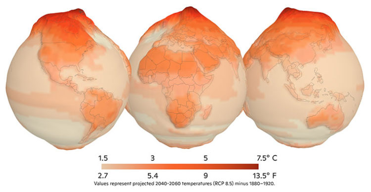
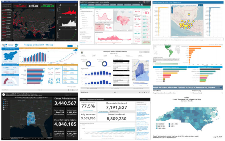
• Membership
  • Newsletter
  • Projects
  • Learning
  • About
  • Member Login
  • Official LEGO world map set

    May 28, 2021

    Topic

    Maps  /  LEGO, world

    We’ve seen maps made out of LEGO bricks before, but LEGO is about to release an official world map set. And cartographers everywhere rejoiced.

  • Members Only

    Visualization Tools and Learning Resources, May 2021 Roundup

    May 27, 2021

    Topic

    The Process  /  roundup

    Here’s the good stuff for May.

  • A short film on giving up privacy, for better or worse

    May 27, 2021

    Topic

    Data Sharing  /  Financial Times, privacy, short film

    We know what you did during lockdown is a short fiction film by Financial Times that demonstrates the challenges of using data for good at the sacrifice of privacy and the complexity of individual lives. Worth the watch.

    [arve url=”https://www.youtube.com/watch?v=4WTpO9y2Dh4″ loop=”no” muted=”no” /]

    I immediately wanted to unplug every single internet-connected device in the house. But of course I did not.

    See also the short film Sight from 2012, which imagines a world where everyone’s reality is augmented with data through digitized contact lenses.

  • Data Underload  /  marriage, work

    Jobs that Marry Together the Most

    Find out which jobs most often pair together among married couples.

    Read More
  • Map shows you where a raindrop ends up

    May 25, 2021

    Topic

    Maps  /  rain, Sam Learner, water

    River Runner is a fun interactive map by Sam Learner. Click anywhere in the contiguous United States to drop some rain and, based on data from the U.S. Geological Survey, the map shows you where the rain ends up and the path it takes to get there.

    This uses USGS NHDPlus data and their NLDI API to visualize the path of a rain droplet from any point in the contiguous United States to its end point (usually the ocean, sometimes the Great Lakes, Canada/Mexico, or another inland water feature). It’ll find the closest river/stream flowline coordinate to a click/search and then animate along that flowline’s downstream path.

    When you think about it, it’s kind of nutty that something like this is even possible. [via Waxy]

  • Hospitalization rates for the unvaccinated

    May 24, 2021

    Topic

    Statistical Visualization  /  coronavirus, vaccination, Washington Post

    Overall, Covid-19 cases and hospitalizations are down in the United States, but much of that is from vaccinations. When you look at only those who are not vaccinated, the rates are still high in many areas of the country. Dan Keating and Leslie Shapiro for The Washington Post show the differences.

  • Four types of people who prevent full vaccination

    May 21, 2021

    Topic

    Maps  /  coronavirus, New York Times, vaccination

    The United States vaccination rate was rolling for a while there, but it has slowed down. Sema Sgaier for NYT Opinion talks about why that is, breaking it down to four general types of people who are hesitant or don’t plan on getting vaccinated:

    After conducting a national survey of U.S. adults, we grouped people into distinct profiles based on their shared beliefs and barriers to getting the vaccine. This approach, borrowed from the marketing world, is called psychobehavioral segmentation. It will allow health officials to target their strategies in ways that ignore demographic categories, like age and race. In the United States, we used this approach to identify five distinct personas: the Enthusiasts, the Watchful, the Cost-Anxious, the System Distrusters and the Covid Skeptics.

    The last two groups will be harder to convince, but for the watchful and cost-anxious, I hope they look at the numbers.

    The risk of side effects is very low (especially when you compare to the everyday things we do to live), your risk of infection or hospitalization goes way down when you get vaccinated, and you don’t have to pay anything.

  • How perception can save lives

    May 21, 2021

    Topic

    Statistical Visualization  /  Lace Padilla, Mission Unstoppable, uncertainty

    Visualization and perception researcher Lace Padilla was on the kid-centric show Mission Unstoppale to talk about visualizing uncertainty:

    [arve url=”https://youtu.be/iJrX-_pIQSc” loop=”no” muted=”no” /]

    I approve of this message.

  • Members Only

    Looking at What’s Not There – The Process 140

    May 20, 2021

    Topic

    The Process  /  bias, missing data

    Data is always incomplete.

  • Most common professional marriages

    May 20, 2021

    Topic

    Statistical Visualization  /  marriage, occupation, San Francisco Chronicle, Susie Neilson

    Susie Neilson for the San Francisco Chronicle compared the marriage of professions in San Francisco against the national average. As you might expect, there were a lot of programmers:

    Perhaps unsurprisingly, the most common union between two professionals here is between a computer programmer and … another computer programmer. Our estimates show that an estimated 1% of all marriages in the region are between two software developers — specifically developers of applications and systems software. For the U.S. overall, software developer unions make up less than one-tenth of a percent of all marriages.

    Back in 2017, I made similar comparisons nationally. I like this local angle. Also, maybe I should look at the most recent numbers.

  • Watercolor Maptiles by Stamen are now part of the Smithsonian’s permanent collection

    May 19, 2021

    Topic

    Maps  /  Cooper Hewitt, Stamen, watercolor

    In 2012, Stamen Design released watercolor map tiles based on OpenStreetMap data. It was amazing to see, especially for a time when most online maps looked about the same. Now these watercolor map tiles are part of Cooper Hewitt, the Smithsonian design museum:

    “Interactive digital works by their very nature subvert traditional museum collecting practices,” said Andrea Lipps, associate curator of contemporary design at Cooper Hewitt. “Watercolor Maptiles is itself a dynamic, living web-based map that is placeless; it exists on a browser and its assets are distributed across servers. By creating a duplicate version of the Watercolor Maptiles site and hosting it on Smithsonian Institution servers and domain, Cooper Hewitt has established a new acquisition model for the museum sector.”

    Amazing.

  • Coping with the big numbers

    May 19, 2021

    Topic

    Infographics  /  comic, Connie Jin, coronavirus, NPR, scale

    Connie Jin, who works for NPR and updates a Covid-19 dashboard, talks about in comic-form feeling numb to the large numbers and how to deal. It comes back to the individual.

  • Statistical Atlas  /  age, generations

    Coming and Going Age Generations

    Since no one has figured out how to defeat time, age generations come and go. This chart shows the generational breakdowns since 1920.

    Read More
  • Transform an image into a pixel-ly visual

    May 17, 2021

    Topic

    Data Art  /  Duc-Quang Nguyen, pixels, R

    Here’s a fun interactive by Duc-Quang Nguyen. Upload an image and get back a transformed visual that uses dots, lines, or ascii. Use the menu options to easily change resolution, colors, and shapes.

    It’s a combination of Georgios Karamanis’s code and Elana Levin Schtulberg’s experiment of the same ilk.

  • Historical shifts in where people live

    May 14, 2021

    Topic

    Statistical Visualization  /  census, population, states, Washington Post

    The places in the United States with the highest populations weren’t always like that. There were shifts over decades. With the recent Census release for state populations, Harry Stevens and Nick Kirkpatrick for The Washington Post go all in with a series of bump charts to show the changes in state population rankings since 1920.

    They point out historical markers along the way, split it up by region, and provide an explorer at the end to look at your states of interest. In the end, it all comes down to weather and air conditioning.

    Still deciding what I think about those gradient connections.

  • Climate normals mapped over time

    May 13, 2021

    Topic

    Maps  /  climate, NOAA, normal

    Every decade the National Oceanic and Atmospheric Administration releases climate normals to provide a baseline to compare current weather against. NOAA just released the estimates for 1991 to 2020. As you might expect, and shown in the maps above, it’s getting hotter.

  • Members Only

    Making a Quick, Custom Prevalence Map – The Process 139

    May 13, 2021

    Topic

    The Process  /  code, R

    This week I’m describing my process behind a quick map. You can download the code at the end of this issue.

  • Map of people moving during pandemic

    May 13, 2021

    Topic

    Maps  /  coronavirus, migration, USPS, Wall Street Journal

    It was only a matter of time before someone showed dots moving across a map to show migration during the pandemic. Again, using USPS change of address data, Yan Wu and Luis Melgar for the Wall Street Journal (paywalled) showed where people moved in the country.

    As shown through other views, a lot of the movement wasn’t out of the ordinary, but in some areas — mainly San Francisco and New York — the pandemic appeared to motivate people a little more to move.

  • Information Graphic Visionaries, a book series

    May 12, 2021

    Topic

    Infographics  /  books, history

    The Information Graphic Visionaries book series just launched on Kickstarter. Emma Willard, Florence Nightingale, and Étienne-Jules Marey are the subjects of three books, each including high-resolution images of the creators’ works and essays that provide historical context.

    Whenever I’m feeling uninspired, I like to flip through old works. It always amazes me what past visualization practitioners were able to make without a computer. Oftentimes the detail and creativity surpass what we see these days. So Visionaries should be a fine addition to the library.

    Just one day in and the Kickstarter is about halfway to the goal.

  • ‘Less than 10 percent’ outdoors

    May 11, 2021

    Topic

    Mistaken Data  /  CDC, coronavirus, New York Times, outdoors

    The CDC said that “less than 10 percent” of coronavirus cases were from outdoor transmissions. David Leonhardt for The New York Times argues why in all likelihood that number is way too high and leads to public confusion:

    If you read the academic research that the C.D.C. has cited in defense of the 10 percent benchmark, you will notice something strange. A very large share of supposed cases of outdoor transmission have occurred in a single setting: construction sites in Singapore.

    In one study, 95 of 10,926 worldwide instances of transmission are classified as outdoors; all 95 are from Singapore construction sites. In another study, four of 103 instances are classified as outdoors; again, all four are from Singapore construction sites.

    This obviously doesn’t make much sense. It instead appears to be a misunderstanding that resembles the childhood game of telephone, in which a message gets garbled as it passes from one person to the next.

  • Page 81 of 392
  • <
  • 1
  • ...
  • 78
  • 79
  • 80
  • 81
  • 82
  • 83
  • ...
  • 392
  • >

Analyze, visualize, and communicate data usefully, beyond the defaults.

Become a member →

Recently for Members

May 15, 2025
Step Chart, Enhanced

May 8, 2025
When the data is not what it seems

May 1, 2025
Finding the Right Charts

April 24, 2025
Visualization Tools, Datasets, and Resources – April 2025 Roundup

April 17, 2025
Breaking Out of Chart Software Defaults

Browse by Chart Type See All →

Gantt Chart Pyramid Chart Table Alluvial Diagram Organogram Moving Bubbles Spiral Chart Square Pie Chart Calendar Beeswarm

Browse By Topic

  • Visualization

    Seeing data

  • Maps

    Seeing geographic data

  • Infographics

    Explaining data

  • Networks

    Connecting data

  • Statistics

    Analyzing data

  • Software

    Working with data

  • Sources

    Getting data

  • Design

    Making data readable

Get the Book

Visualize This: The FlowingData Guide to Design, Visualization, and Statistics

Available now.

Order: Amazon / Bookshop

Made by FlowingData

  • The Process

  • Data Underload

  • Chart Everything

  • Guides

  • Books

  • Shop

  • About
  • Contact
  • Newsletter
  • LinkedIn
  • Instagram
  • Bluesky
  • RSS
Copyright © 2007-Present FlowingData. All rights reserved.