The New York Times highlights the work of True Price Foundation, a group that estimates the environmental and social costs tied to food production that aren’t included in the price you see at the grocery store. Impact from carbon emissions, water pollution, and poor working conditions find their way into our lives later in the form of climate change, loss of species, and required healthcare.
-
How to Map with Contour Lines and GeoTIFF in R
GeoTIFF data can provide high granularity but make it hard to see patterns when data is sparse. Contour lines provide an aggregated view that makes patterns easier to see.
-
Any day is a good day for a map of predominant commercial chains. For The Washington Post, Kevin Schaul and Jaclyn Peiser show the most common grocery owners, creating territories within the United States. Albertsons, also the owner of Safeway and Vons, dominates the northwest, and Walmart has its hands just about everywhere, but especially owns a stronghold on the midwest.
On methodology:
Grocery store addresses comes from OpenStreetMap, a community-driven effort to populate maps with location data. The Post pulled locations in the United States identified as supermarkets, as well as Walmart, Sam’s Club, Target and Costco. The map visualizes the influence of the nearest grocery store locations using a k-nearest neighbor analysis that falls off as the distance to a stores increases. Grocery stores with unique names were excluded from this analysis.
There is also a search feature that lets you see the common stores in your county, beyond the leading owner.
-
For Bloomberg, Elena Mejía and Shawn Donnan use a transitioning cartogram to show how immigration might play a role in the upcoming election:
In the battleground states that will decide this November’s election, about 72% of migrants in 2023 went to Biden counties while less than a third went to Trump counties, the Bloomberg analysis found. Counties that voted for Biden four years ago are home to roughly 60% of the overall US population.
-
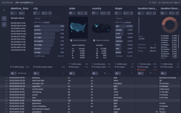
Fathom Information Design, known for client visualization-centric projects, introduced Rowboat. It’s a tool that lets you load large CSV files or Excel spreadsheets quickly in the browser. See summary graphics for each column, filter based on criteria, and quickly explore the dataset.
It’s surprisingly fast for running in the browser. I threw a couple hundred megabytes at it and the view loaded in a few seconds. So I threw in half a gigabyte and it still did fine. The tool did not like a file over a gigabyte. It seemed to really not like files with a lot of columns even though they were relatively small.
So Rowboat is currently focused on a specific set of tasks with a certain type of data, and it works well at that. Most of the tool is free for now, but there a paid tier that lets save data and export reports.
-
For The Washington Post, Andrew Van Dam and Lenny Bronner analyzed names and political leanings, using a voter file with 212 million registered voters. They break it down by age and geography. You can also search for your own name.
As with most trends related to political leanings, the patterns found in names run closely with demographic shifts, such as a name that grows more common among a race group and less common in another.
-
For The Pudding, Matthew Daniels extracted all the outdoor basketball courts in the United States via OpenStreetMap satellite imagery. With 59,705 locations along with commenting and liking, it’s a fun experiment in scale for display, filtering, and interaction. Plus, basketball.
-
Members Only
-
China recently increased their retirement age to 63 for men and 55 for women (and 58 for female civil servants). Even with the adjustment, the country is still on the lower end when compared to other countries.
-
Nicola Rennie provides five quick tips to improve on default axis scales:
[T]he choice of axes can have a big impact on the clarity of your visualisation, and that relying on the default settings of software isn’t always a good idea. Are there blanket rules about axes that you can apply to every type of visualisation? No. Instead, I’d advocate for having a little bit of common sense and actively thinking about your design choices. Think about the context of what you’re trying to communicate, and whether or not your data visualisation of choice communicates that effectively and honestly.
When I hear “common sense” I’m reminded of when my dad would tell me to use common sense when I did something that didn’t make much sense in retrospect. Whatever I was doing seemed like a good idea at the time. So I’d argue not to use common sense with your axes, but to avoid defaults by default until you develop a better feel for how to communicate with data.
-
Normal retirement age, also known as full retirement age, is 67 years old for those born in 1960 or later. It’s when you can get full Social Security benefits (assuming they still exist). It’s common for people to stop working before this age, but they’re veering older.
-
Here’s a fun interactive from NASA Landsat that lets you enter your name to see it spelled with satellite imagery. There are multiple images for each letter, so you get a new combination when you refresh.
I didn’t know NASA put out these kind of projects, but I like it. You can also download the images for specific letters.
-
Every two years, since 2012, the North American Cartographic Information Society publishes Atlas of Design. It’s a collection of beautiful maps and the process behind each. From series editor Nat Case, on how traditions in cartography can still feel new:
This is one of the magical things about how people depict the world. Even if the point of the depiction is one you’ve seen or heard a thousand times, if you tell it right, a love song or a portrait or an action movie can still take your breath away. And even the maps that look like maps you’ve seen before, when they work right, can do that too. We hear a familiar tune, we see that same old story…and the map is still fresh and glorious, and we just want to dive in and explore it.
Speaking of exploration, there is a riddle at the end of the volume that relies on a clue from each map in the book. I’m nearly certain I’ll never figure it out, but maybe you can. Atlas of Design, the seventh volume, is available for pre-order and comes out next month. You can also purchase previous volumes, which are nice to have on the shelf with their uniform bindings.
-
Members Only
-
This is one small bit in a Reuters piece by Mariano Zafra and Sudev Kiyada about highly flammable materials in buildings constructed in the 1980s. The polyethylene cores usually come as a thin layer in panels, but they cover the whole building, which can lead to fast flames. I appreciate the fingers to indicate the thinness.
-
Since weather and land availability vary across the country, so do the crops. This is the cropland geography of the United States.
-
For The Washington Post, Anahad O’Connor and Aaron Steckelberg show the contrast between making unrefined avocado oil, which is more natural, and refined avocado oil, which is more processed. The former is more like pressing a bunch of avocados, whereas the latter is, well, more involved and uses unnatural ingredients.
Mostly, I am here for the anthropomorphized seeds, but now I also wonder where the rest of my cooking oils come from. It’s sad that we have no clue.
-
AI models are trained on data, and better data helps make better models. Likewise, it’s hard to develop worthwhile models with bad data. So what happens when it grows more difficult for AI-based bots to scrape the web and more of the available data is generated via AI in the first place? For NYT’s the Upshot, Aatish Bhatia imagines a feedback loop of numbers and letters that grow fuzzier with each generation.
-
Natural diamonds require a lot of pressure and time, and then someone has to mine for them. Lab-grown diamonds can be produced to be nearly indistinguishable from the natural ones, minus the time and mining. For Works in Progress, Javid Lakha describes the process and the growing cost gap between natural and the cheaper lab-grown.
As the value of diamonds inevitably falls, do engagement rings turn towards something more rare?
-
In the conterminous United States, most of the barren land belongs to deserts and mountains in the west.