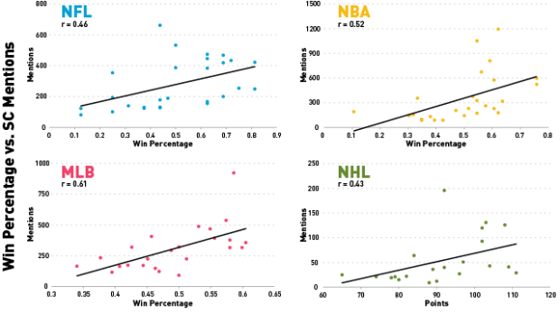
Meta. Is it people’s interest, or is it actually 50 percent of statistics in the news are worthless numbers that were plugged in to make a story sound more factual?
-
-
Members Only
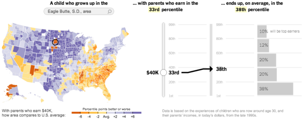
When presented with a static graphic, it can be useful to see specific values after you see overall patterns. This tutorial shows you how to add simple interactions to a choropleth map so you can get specifics for regions.
-
I knew things were bad, but I didn’t know they were this bad. Obama has his work cut out for him. [Thanks, @adamsinger]
-
After seeing this post that highlights racist tweets after the election, Floating Sheep took a closer look at the geography. Using an estimate that takes into account number of tweets per state, the southeast came out green.
So, are these tweets relatively evenly distributed? Or do some states have higher specializations in racist tweets? The answer is shown in the map [above] (also available here in an interactive version) in which the location of individual tweets (indicated by red dots) are overlaid on color coded states. Yellow shading indicates states that have a relatively lower amount of post-election hate tweets (compared to their overall tweeting patterns) and all states shaded in green have a higher amount. The darker the green color the higher the location quotient measure for hate tweets.
I wondered about Asian remarks after seeing this, but a quick search was depressing and I stopped. [Thanks, Matt]
-
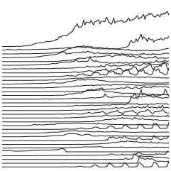
In 1979, Joy Division released their album Unknown Pleasures, and the cover was an image of readings from a pulsar. That image grew into a cultural phenomenon. With the kick off of the new Visualized conference in New York, this short video explores the growth of the icon. [Thanks, Eric]
-
Amanda Uren has a fun collection of map-like scans from the 11th century. Some of them are geographic, but most of them are more like rough sketches of how the individual saw the area the image represents. It’s like those stereotype maps that people like to make, except no one’s trying to be funny.
-
-
-
By way of Rafa Irizarry from Simply Statistics, a plot of Nate Silver’s probabilities for Barack Obama winning a state versus the percentage of vote in each state, as of midnight EST.
I guess that’s pretty (100%) good. Looks like the folks at Princeton didn’t do half bad either. It’s a win for Obama and a win for statistics. Well, good statistics, at least. (Looking at you, University of Colorado.)
Update: Drew Linzer at Emory and the Huffington Post Pollster also did well. All in all, it was a good night for statistics.
-
-
As the results roll in tonight, you have plenty of options to keep track of who won what and where. These should cover all of your bases.
New York Times coverage — Up to their old tricks, they have a map, big board, and network calls. The paths to the White House interactive will also be updating live.
NPR big board — Updating every 15 seconds, this is the display that NPR hosts and election staff are watching. And of course, there’s also news coverage.
Huffington Post map — Like the others, updates every 30 seconds. Also indicates where polls have closed.
Is Obama president? — Finally, if all you care about now is the result, the minimalist Guardian and Real Clear Politics collaboration provides that. See also Romney version.
(There are a ton more, but these are the ones I’ll be watching.)
-
-
Following their animated and narrated visualization on political contributions over time, VisPolitics maps Boston political donations in MoneyBombs.
This video of the Boston metropolitan area reveals the geographic distribution of political donations made by individuals throughout 2012. We identify two types of temporal bursts of campaign contributions. We call both “moneybombs” because they reveal a temporal clustering. The first type occurs when many small donations are given on the same day to a candidate. We call this a grassroots moneyb omb. The second are bursts of extremely large donations, that take advantage of campaign finance laws and allow individuals to donate more than the traditional $5,000 limit. We call this the Joint Committee moneybomb.
Like in the first project, the narration provides a clear view of the data in front of you. There are also videos for just presidential donations and Republican and Democratic donations.
[Thanks, Mauro]
-
-
-
-
With the election tomorrow, Mike Bostock and Shan Carter for the New York Times map the 512 possible paths to the White House. Select state wins, and the paths update accordingly. For example, select an Obama win in Florida, and it doesn’t look good for Romney.
If Mr. Romney loses Florida, he has only one way to victory: through all the other battleground states. He has led most polls there, however, and is the favorite. If Mr. Romney wins Florida, he has 75 paths open to him.
The interaction feels game-like.
-
In something of an homage to the Genealogy of Pop & Rock Music by Reebee Garofalo, designer Larry Gormley visualized 100 years of film.
This graphic chronicles the history of feature films from the origins in the 1910s until the present day. More than 2000 of the most important feature-length films are mapped into 20 genres spanning 100 years. Films selected to be included have: won important awards such as the best picture Academy Award; achieved critical acclaim according to recognized film critics; are considered to be key genre films by experts; and/or attained box office success.
Available in print for 34 bones.
-