The New York Times mapped ratings for members of Congress, as given by…
Maps
Intuitive to look at spatial patterns and great for distributing geographic data.
-
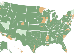
National Rifle Association grades for Congress members →
-
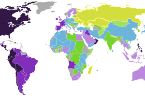
Emotion of countries mapped →
Max Fisher for the Washington Post mapped country emotion ratings, based on the…
-
Link
Cartograms in D3 →
Cartograms in D3. Way smooth and interactive.
-
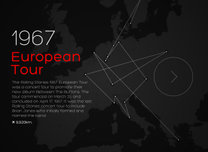
50 years of Rolling Stones tours
CartoDB mapped every Rolling Stones tour from 1963 to 2007.
The Stones passed… -
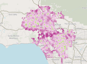
Los Angeles Fire Department response times
Ben Welsh, Robert Lopez, and Kate Linthicum for the Los Angeles Times analyzed…
-
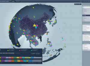
FIFA development work around the world →
Studio NAND and Moritz Stefaner, along with Jens Franke explore FIFA development programs…
-

Beautiful interactive tour of the galaxy
In a beautiful rendition of the galaxy, Google visualized 100,000 stars, starting at…
-
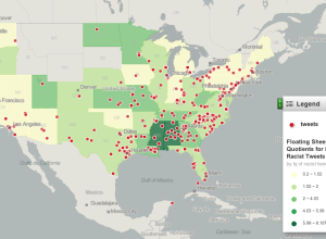
Mapping racist tweets
After seeing this post that highlights racist tweets after the election, Floating Sheep…
-
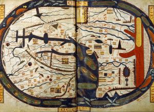
Maps before maps
Amanda Uren has a fun collection of map-like scans from the 11th century.…
-
2012 political donations mapped over time
Following their animated and narrated visualization on political contributions over time, VisPolitics maps…
-
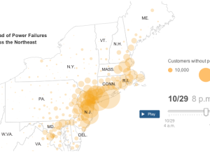
Sandy aftermath: Power outages and flooding →
The New York Times provides a detailed look at the Sandy aftermath, across…
-
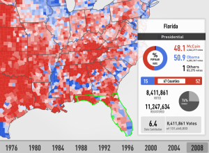
Browse elections data back to 1976 with Electionary app
Electionary, the new iPad app from TargetPoint Consulting, lets you browse national election…
-
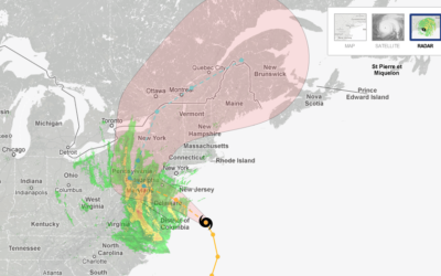
Hurricane tracker for Sandy
The New York Times has an updated version of their hurricane tracker up…
-
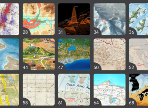
Insisting on beautiful maps
In the Atlas of Design, published by the North American Cartographic Information Society,…
-
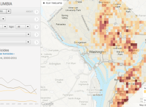
Tracking homicides in Washington, D.C. →
In a multipart special report, The Washington Post investigated homicides in the nation’s…
-
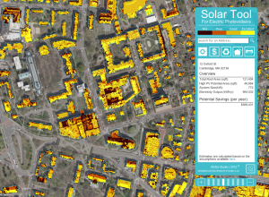
Solar energy potential, mapped in Cambridge →
Sustainable Design Lab at MIT and MoDe Studio estimated the potential hotspots for…
-
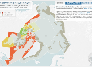
State of polar bear populations
There are an estimated 20,000 to 25,000 polar bears in the world, and…
-
Game: Match states on a blank map →
In case you’re interested in learning how much you suck at US state…
Recently for Members
Second Edition
 Visualize This: The FlowingData Guide to Design, Visualization, and Statistics (2nd Edition)
 Visualize This: The FlowingData Guide to Design, Visualization, and Statistics (2nd Edition)
New tools, refined process.
Browse by Chart Type See All →


