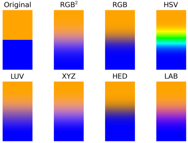
• Sometimes it can be a challenge to produce data graphics in vector format, which is useful for high-resolution prints. Raw, an alpha-version tool by Density Design, helps make the process smoother.

    Primarily conceived as a tool for designers and vis geeks, Raw aims at providing a missing link between spreadsheet applications (e.g. Microsoft Excel, Apple Numbers, OpenRefine) and vector graphics editors (e.g. Adobe Illustrator, Inkscape, Sketch). In this sense, it is not intended to be a full “visualization tool” like Tableau or other similar products: as the name suggests it is a sketch tool, useful for quick and preliminary data explorations as well as for generating editable visualizations.

    Although still in its early stages, Raw is actually quite useable. Start with a dataset copy and pasted from your spreadsheet, select a visualization format, and then click-and-drag how you want to represent values. Modify options as you see fit and download in the format you need.

  • Last year, URL shortening service bitly and Forbes made a map that showed popular news sources by state. However, the map was based on a static month of data, so what it showed then doesn’t necessarily apply to now. Bitly took it a step further this year and shows media consumption in real-time.

    They also categorized media sources into newspapers, tv and radio, magazines, and online only for a more detailed view. And to top it off, you can click on states to see a list of top sources, and you can see links driving traffic to the listed sites.

    One key thing to keep in mind as you read the maps: They show disproportionality rather than raw counts. So when you see that Texas is a TMZ fiend, that doesn’t mean they click more on the celebrity news site more than on Huffington Post. Rather, it means the relative volume of TMZ-clicking from Texas versus other states is higher versus the relative volume of Huffington Post-clicking.

  • I’m at an age where my feed is filled with data points. Every day my friends post about their data points, how precious their data points are, and all the peculiarities of their data points. Even though there are hundreds of thousands of data points that pop up every day, each one is a gift that can be compared to nothing and no one else. At the most superficial level, yes, they are easy to compare, but once you look to the details — a wink, a smirk, a bobble — you see individuals, and that’s where we seem to find the most joy.

    I’ll let you know in a few weeks.

    My wife just went on maternity leave, in preparation for our very own data point.

    It’s our first, so I’m not sure how this works, but something tells me I’ll be busier and maybe more tired than usual. I hope to keep FlowingData running, as if nothing changed, but in case you don’t hear from me for a few days, you’ll know why.

  • The video below shows ten seconds of trading on Blackberry on October 2, when they reported a bigger loss than they thought. It might also be a super advanced level of Space Invaders.

  • Mark Graham and Stefano De Sabbata for Information Geographies mapped the most visited site based on Alexa data. Countries are sized by Internet population. There aren’t many surprises with Facebook and Google in the Americas and and Europe, but it gets more interesting when you look elsewhere.

    The situation is more complex in Asia, as local competitors have been able to resist the two large American empires. Baidu is well known as the most used search engine in China, which is currently home to the world’s largest Internet population at over half a billion users. At the same time, we see a puzzling fact that Baidu is also listed as the most visited website in South Korea (ahead of the popular South Korean search engine, Naver). We speculate that the raw data that we are using here are skewed. However, we may also be seeing the Baidu empire in the process of expanding beyond its traditional home territory.

    The remaining territories that have escaped being subsumed into the two big empires include Yahoo! Japan in Japan (in join venture with SoftBank) and Yahoo! in Taiwan (after the acquisition of Wretch). The Al-Watan Voice newspaper is the most visited website in the Palestinian Territories, the e-mail service Mail.ru is the most visited in Kazakhstan, the social network VK the most visited in Belarus, and the search engine Yandex the most visited in Russia.

  • When you go to the United States Census site, Data.gov, or similar government-run sites, you see this. “Due to the lapse in government funding, census.gov sites, services, and all online survey collection requests will be unavailable until further notice.” Now it’s personal.

  • Big data, in all its glory, promises insights into the soul of humankind. There’s a hefty restriction though. Data only tells you about the population and actions of individuals it represents, which inevitably excludes part of the population. Jonas Lerman considers two hypothetical people. The first one:

    The first is a thirty-year-old white-collar resident of Manhattan. She participates in modern life in all the ways typical of her demographic: smartphone, Google, Gmail, Netflix, Spotify, Amazon. She uses Facebook, with its default privacy settings, to keep in touch with friends. She dates through the website OkCupid. She travels frequently, tweeting and posting geotagged photos to Flickr and Instagram. Her wallet holds a debit card, credit cards, and a MetroCard for the subway and bus system. On her keychain are plastic barcoded cards for the “customer rewards” programs of her grocery and drugstore. In her car, a GPS sits on the dash, and an E‑ZPass transponder (for bridge, tunnel, and highway tolls) hangs from the windshield.

    That’s a lot of data. The second person:

    He lives two hours southwest of Manhattan, in Camden, New Jersey, America’s poorest city. He is underemployed, working part-time at a restaurant, paid under the table in cash. He has no cell phone, no computer, no cable. He rarely travels and has no passport, car, or GPS. He uses the Internet, but only at the local library on public terminals. When he rides the bus, he pays the fare in cash.

    The second person has fewer data flows.

    These days, big data exclusion almost sounds like a good thing — if you’re intent on avoiding all marketing-related data collection — but when policy-making, fund allocation, etc. come into play, it’s possible the excluded aren’t counted. That’s not to say people should hurriedly sign up for Facebook and opt-in to every tracking study. It’s the opposite. Those in charged of the data and those who decide based on what they see in the data are responsible for knowing the background of their source.

  • Measuring and Mapping Space: Geographic Knowledge in Greco-Roman Antiquity opens at Institute for the Study of the Ancient World of NYU, this Friday. The exhibit serves as an appreciation of maps and more importantly, the history behind them and what they represent of their time.

    Our modern knowledge of ancient cartography relies almost exclusively on written sources. Despite this paucity of ancient artifacts, it is clear that Greeks and Romans applied topographical studies to the mapping of land and sea routes, to the implementation of an accurate system of recording public and private lands, and to promote specific political agendas. In all these instances, the resulting representations of places presented the viewer with a distorted and schematized version of geographic and topographic elements, transforming those regions both on a conceptual and on a physical level.

    [via The New York Times]

  • Mike Bostock, Shan Carter, and Kevin Quealy for The New York Times explore quarterback streaks in the National Football League since 1970. The longest streak for each team is highlighted yellow, and you can search for your favorite players either by mousing over streaks or via the dropdown/search menu.

    Be sure to also check out the chart iterations of the interactive. First, a couple of bar graphs in R for a visual summary, and then 17 sketches later, out comes the finished product.

    I’m surprised that many of the longest streaks took place in the 1970s and 1980s. You’d think with today’s rules, there’d be more in the latter half of the timespan. Then again, trades and quarterback rotations aren’t the same as they were back then either.

  • Foursquare check-ins can be self-encapsulated and personal to the individual, where each dot represents a specific place in time. Each point represents a stop at a restaurant, store, or place of business. However, look at check-ins from lots of people and movement appears, which is the premise of Foursquare’s latest videos.

    Because it’s Foursquare, there’s an added dimension of location categories, so color codes show people go to work, grab lunch, shop, and get after-work drinks.

    The above shows the pulse of Tokyo. See also: Chicago, London, Istanbul, San Francisco, and New York. [via Fast Company]

  • A while back we saw a size comparison of random spaceships. That one pales in comparison to this extensive version by Dirk Loechel. It’s got ships from Star Wars, Star Trek, EVE, Babylon 5, Starship Troopers, Titan A.E., and oh so much more.

    Be sure to see the full-sized version here. [via Kotaku]

  • The Ordnance Survey, the national mapping agency for Great Britain, mapped 220,000 square kilometers of the mainland with 22 billion blocks in Minecraft.

    Each blocks represents a ground area of 50 square metres. The raw height data is stored in metres and must be scaled down to fit within the 256 block height limit in Minecraft. A maximum height of 2 500 metres was chosen, which means Ben Nevis, appears just over 128 blocks high. Although this exaggerates the real-world height, it preserves low-lying coastal features such as Bournemouth’s cliffs, adding interest to the landscape.

    Just download the free archive, load it in Minecraft, and explore. [via NextWeb]

  • In a step-by-step narrative, produced by Adam Becker, MacGregor Campbell and Peter Aldhous for New Scientist, is an exploration of possible Earths light years away. Possible planets are marked based on the amount of light they block from their parent star, and then those are filtered based on size and whether or not orbits are in a habitable zone, which leaves possible Earths.

    The Kepler telescope did this for a relatively small spot in the sky for four years and found a handful of possible Earths. When you extrapolate, there are many more. [Thanks, Peter]

  • Projection mapping is the art of using physical objects as display surfaces and turning them into something else visually. This video of Box is an impressive demonstration of the technology.

    “Box” explores the synthesis of real and digital space through projection-mapping on moving surfaces. The short film documents a live performance, captured entirely in camera. Bot & Dolly produced this work to serve as both an artistic statement and technical demonstration. It is the culmination of multiple technologies, including large scale robotics, projection mapping, and software engineering. We believe this methodology has tremendous potential to radically transform theatrical presentations, and define new genres of expression.

    I would’ve thought this was CGI if I didn’t know any better.

  • Moving on from the most trendy names in US history, let’s look at…

  • It can be difficult to imagine the scale of planets and moons, because (1) they’re really big and (2) they’re far away. From where we are, the stars look pretty small, but in reality, they shiny objects might be several times larger than our own planet. In this straightforward interactive, Brian Lukis shows how planet and moon sizes compare. Simply select between the apparent view and the absolute to see how perspective seemingly changes size.

  • In the latest SIAM Journal on Applied Mathematics, Chaturapruek, et al. describe modeling criminal movements based on where potential criminals live and areas of interest.

    Data available on distance between criminals’ homes and their targets shows that burglars are willing to travel longer distances for high-value targets, and tend to employ different means of transportation to make these long trips. Of course, this tendency differs among types of criminals. Professionals and older criminals may travel further than younger amateurs. A group of professional burglars planning to rob a bank, for instance, would reasonably be expected to follow a Lévy flight.

    “There is actually a relationship between how far these criminals are willing to travel for a target and the ability for a hotspot to form,” explain Kolokolnikov and McCalla.

    I hear the RV and Pontiac Aztec is the preferred mode of transportation among high school chemistry teachers turned meth cooks.

    Full paper here, if you’re into that.

  • Probublica has a detailed piece on the potential overuse of acetaminophen, commonly known as Tylenol. The photo above, which compares the maximum amount of acetaminophen allowed in a single package, caught my eye. I like the use of jars to provide a second dimension of comparison, versus the formless piles or incongruous containers that we usually see in these photo comparisons.

    Of course the next step is to look at dosage restrictions overall for the full comparison. [via @sisiwei]

  • When you look for overall trends, you often poke around the data in aggregate, but when you zoom out too far, you could miss details or within-category variation. Sometimes when you zoom in, you see a completely opposite trend of what you saw overall. This is known as Simpson’s Paradox. Lewis Lehe and Victor Powell explain in a series of small, interactive charts.

    Why does this matter?

    Simpson’s paradox usually fools us on tests of performance. In a famous example, researchers concluded that a newer treatment for kidney stones was more effective than traditional surgery, but it was later revealed that the newer treatment was more often being used on small kidney stones. More recently, on elementary school tests, minority students in Texas outperform their peers in Wisconsin, but Texas has so many minority students that Wisconsin beats it in state rankings. It would be a shame if Simpson’s paradox led doctors to prescribe ineffective treatments or Texas schools to waste money copying Wisconsin.

    The takeaway lesson: Remember to look at the details. [Thanks, Victor]

  • In the continued series of meta-data-driven maps, OpenStreetMap shows the work of individuals across the online community.

    OpenStreetMap is created every day by thousands of users logging in and improving the map. Here is a visualization of this amazing social fabric of individuals working together. We generated a color for each road segment from the user ID of the mapper who last edited it to show how many individual contributions large and small add up to a collaborative map of the world. Take a look at how many people have been mapping near you.

    Areas that resemble a Pollock painting represent many contributors in a single area, whereas more solid colors represent uploaded databases and more major contributors.

    Be sure to see the full-sized interactive version.