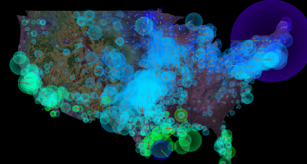
• Nicolas Rapp and Anne Vandermey with a straightforward look at new jobs added at the top 100 companies to work for, according to Fortune.

    Fat paychecks, sweet perks, fun colleagues, and over 70,000 jobs ready to be filled — these employers offer dream workplaces. Like Google, which reclaims the top spot this year to become a three-time champion. Meet this year’s top 100, network with the winners on LinkedIn, and more.

    Number of new jobs added or lost is on the horizontal, and number of employees at the start of the year on the vertical. Bubble size represents number of job applicants.

    There were 7.6 million applicants to Starbucks last year. That’s insane.

    [Nicolas Rapp]

  • Eric Fischer has mastered the art of making use of geotagged things from social sites like Twitter and Flickr. In his most recent set, Fischer maps connectedness via geotagged tweet density (using Dijkstra’s algorithm). I just got back from Berkeley a few hours ago, so the map of East Bay travels is of most interest to me.

    The main implication, as far as I am concerned, being that because of its traditional focus on downtown commuters, BART does not do a very good job of serving the most promising corridor in Berkeley and North Oakland, which would run approximately under San Pablo, University, the UC Berkeley campus, Telegraph, a jog over to College, Broadway, 40th/Linda, Grand, and some sort of route from the Grand-Lake district crossing Park Boulevard to near 14th and Foothill. Some of this, especially at the south end, would be difficult because of topography, but it could probably be approximated. Needless to say, if this were to be constructed, it would have to be pretty much entirely in subway to avoid tearing down the neighborhoods it would intend to serve.

    There are also maps for New York and Chicago.

  • Anyone who uses a social music service like Rdio or last.fm has probably noticed an album’s sudden rise in popularity after certain events. For example, when Amy Winehouse died, her album received exponentially more plays than usual. Other times the increase in plays for a certain artist is simple, like the release of a new album. Last.fm takes a look at these patterns in 2011 through the lens of scrobbles, which is basically how last.fm users log what they’re listening to.

    Download the data here [zip file] and have a go yourself.

    [Last.fm | Thanks, @dwtkns]

  • ProPublica has been tracking members of Congress who oppose and support SOPA. You can view by party and chamber, and you can even sort by campaign contributions from movie, music, and television. Above shows the quick change from January 18 to 19.

    [ProPublica]

  • After seeing Tristan Louis’ list that tallied the streaming availability of 2011’s top 100 box office hits, I was curious what it looked like graphically. So I put together this little number. Blue means available, yellow means not, and gray means it’s only available for purchase. The last column for DVD simply means it’s available (since DVDs are of course not streaming).

    Netflix streaming still isn’t a place to find the big movies (as any Netflix customer can tell you), with only five of the top 100 available. There is greater streaming availability from iTunes, Amazon, and Vudu, but those of course aren’t fair comparisons to Netflix, given that the latter is subscription-only.

    My main takeaway is that if you’re deciding between the non-subscription services, it looks like price is the main thing to look at, since there doesn’t seem to be much variability in availability (although it could be different for smaller movies). As for Netflix, subscribe for the television and for the movies less so.

    [Tristan Louis via Waxy]

  • Using Color Scales and Palettes in R

    Color can drastically change how a chart reads and what you see in your data, so don’t leave it up to chance with defaults.

  • In working with tenants to help their city attorney convict a group of slumlords, an economic justice organization collected public data on housing violations that were going unfixed. They tried standard mind mapping and organization software, but the relationships were too complex to unearth anything useful. So they eventually used social network analysis, revealing money exchanging hands in such a way that allowed owners to strip the value from buildings without actually fixing them.

    The analysis results, combined with the city’s investigation, allowed key convictions and court-awarded finances for tenants to move elsewhere.

    Sounds like a good reason for Data Without Borders.

    [Valdis Krebs via kottke]

  • In 2010, NASA released a map that shows world forest heights. Robert Simmon, using data from The Woods Hole Research Center, has produced an even higher resolution map, down to the management scale:

    In the end, the research team was able to construct a map with higher resolution and more precise detail than any large-scale map of forest biomass ever made. The map reveals the checkerboard patterns of logging in the old growth of the Pacific Northwest and the highly managed tree farms of the Southeast. In the Midwest, trees outline the rivers and the edges between farms, while forests re-emerge on land that was once cleared for crops. In the Mid-Atlantic and New England, lands that were stripped bare in the early years of the nation are now tree-covered again—though with many urban developments amidst the forest.

    [NASA | Thanks, Michael]