For Bloomberg, Krishna Karra and Stephen Wicary map blackouts in Cuba due to…
Maps
Intuitive to look at spatial patterns and great for distributing geographic data.
-
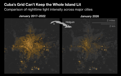
Maps show not enough electricity in Cuba
-
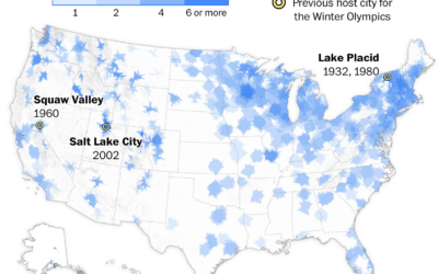
Access to Winter Olympic sports near you
While it’s easy to go out for a run in most places, finding…
-
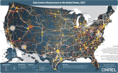
Map of data center infrastructure
More processing power requires more data centers, and for better or worse, they…
-

IsoCity, an open source city building game
If you’re a fan of SimCity, then you’ll appreciate IsoCity, an open source…
-

Mapping 200-mile formation of Chinese fishing boats
For the New York Times, Chris Buckley, Agnes Chang, and Amy Chang Chien…
-

Falling vaccination rates in schools
In some counties, vaccination rates increased after the pandemic, which got them past…
-

Flight patterns when an exploding SpaceX Starship fills the sky with garbage
A SpaceX rocket explosion elicits images of spectacle and maybe thoughts of a…
-

Imagining a global lottery where you are born with less
To highlight challenges in other countries, Giving What We Can imagined a birth…
-

Network of deportation
The current administration is bent on deporting people from the United States. For…
-

Climate change driving home insurance higher
As hurricanes and wildfires grow more common in some areas, home values go…
-

Geologic map of the United States’ surface
The United States Geological Survey published composite maps and data for the country’s…
-

Mapping the most dangerous intersections for pedestrians
For the Washington Post, Ian Duncan, Emmanuel Martinez, and Dylan Moriarty analyzed traffic…
-

Visual reconstruction of flooding at Camp Mystic
The New York Times used a mix of media and data sources to…
-

Scientists can track individual butterflies with tiny sensors
Monarch butterflies somehow fly from Ontario, Canada to Mexico City, but the migration…
-

Shifts back to the left for Hispanic voters
In 2024, Hispanic voters in New Jersey took a hard shift to the…
-

Imagining an extreeeeeme gerrymandered future
Section 2 of the Voting Rights Act prevents states from discriminating by race…
-

Damage by Hurricane Melissa, seen through satellite imagery
Melissa was the strongest storm to ever hit Jamaica, and the country was…
-

With new rules for disability insurance, states that will be affected the most
The administration aims to make it harder to claim disability insurance. Eli Hager,…
Recently for Members
Second Edition
 Visualize This: The FlowingData Guide to Design, Visualization, and Statistics (2nd Edition)
 Visualize This: The FlowingData Guide to Design, Visualization, and Statistics (2nd Edition)
New tools, refined process.
Browse by Chart Type See All →


