• Membership
  • Newsletter
  • Projects
  • Learning
  • About
  • Member Login
  • Sonification of Stanley Cup goals →

    July 10, 2012

    Topic

    Data Art  /  hockey, sonification, Stanley Cup

    Artist Bard Edlund sonified the goals during the 2012 Stanley Cup.

    The goals tally cumulative scoring for each team (rather than goals against). When a puck crosses the goal line, a musical note plays. There’s one instrument sound for Western Conference teams, and another for Eastern Conference teams. Higher-seeded teams are assigned a higher pitch. This means you can actually hear whether higher- or lower-seeded teams are scoring more, and if Western or Eastern Conference teams are producing more goals.

    The beat in the background almost makes it sound like an actual song.

  • Soda versus pop on Twitter →

    July 9, 2012

    Topic

    Statistics  /  soda, Twitter

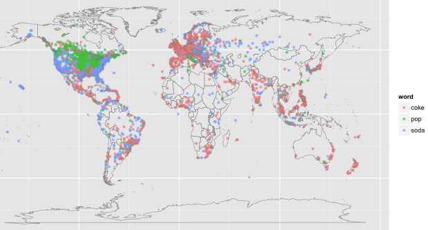
    Edwin Chen, a data scientist at Twitter, explored the geographic differences in language usage of soda, pop, and coke. We’ve seen this before, so it shouldn’t be surprising to see that in the United States soda is dominant on the coasts, pop in the midwest, and coke in the southeast. The global view is new, with coke basically penetrating almost all of Europe.

    What I think is most interesting though is the idea of tweets and status updates as data that represents cultures. There are applications that keep track of tweet volume, number of replies, and when the best time to share a link is, but in ten years none of that will matter. These miniature data time capsules on the other hand will be worth another look.

  • Evolution of the Formula One car, animated

    July 9, 2012

    Topic

    Infographics  /  animation, racecar

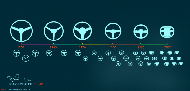
    Animator and illustrator Rufus Blacklock animated 60 years of Formula One race car design. The outline of each year’s car morphs from design to design, the engine shifts location, and the steering wheel changes shape. The video as a whole is pretty sexy.

    He also took a look at just the steering wheel’s evolution. I’m almost certain the next iteration will be non-existent in the future, where only robots race. Speaking of which, whatever happened to Robot Wars? That was good entertainment.

    [via Revolutions]

  • Mitt Romney pseudo-venn diagram, used incorrectly

    July 8, 2012

    Topic

    Mistaken Data  /  Mitt Romney, venn diagram

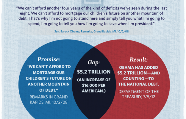
    The Mitt Romney campaign put this venn diagram up a few days ago, aiming to show the “promise gap.” On the left is an Obama promise, and on the right is the result. In the middle, the combination of the promise and the result, is the gap. Wait, that’s not right.

  • A year of global cloud coverage →

    July 6, 2012

    Topic

    Maps  /  animation, environment, New York Times

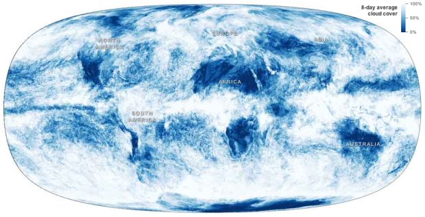
    Jonathan Corum for the New York Times mapped cloud coverage from April 2011 to April 2012.

    At any moment, about 60 percent of the earth is covered by clouds, which have a huge influence on the climate. An animated map showing a year of cloud cover suggests the outlines of continents because land and ocean features influence cloud patterns.

    So if I’m understanding it right, the continent boundaries come straight from the cloud data, provided by NASA Earth Observations. No lines are drawn underneath, which is kinda awesome. [via @datapointed]

  • Beer versus church mapped →

    July 6, 2012

    Topic

    Maps  /  beer, church, Floatingsheep

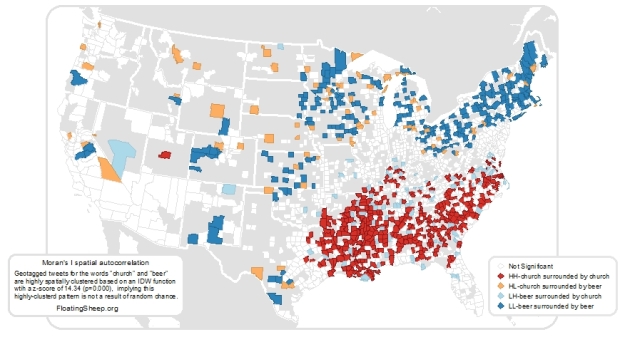
    The geographers at Floatingsheep are at it again, this time comparing tweets that mention beer and those that mention church.

    Given the cultural content of the “church” tweets, the clustering of relatively more “church” than “beer” content in the southeast relative to the north-east suggests that this could be a good way to identify the contours of regional difference. In order to quantify these splits, we ran a Moran’s I test for spatial auto-correlation which proved to be highly significant as well. Without going into too much detail, this test shows which counties with high numbers of church tweets are surrounded by counties with similar patterns (marked in red) and which counties with many beer tweets are surrounded by like-tweeting counties (marked in blue). Intriguingly there is a clear regional (largely north-south split) in tweeting topics which highlights the enduring nature of local cultural practices even when using the latest technologies for communication.

    I wonder if searches for “ate too much” or “out for a run” would match up with obesity trends. Hopefully their Data on Local Life and You (DOLLY) project comes to fruition.

  • Page 269 of 392
  • <
  • 1
  • ...
  • 266
  • 267
  • 268
  • 269
  • 270
  • 271
  • ...
  • 392
  • >

Analyze, visualize, and communicate data usefully, beyond the defaults.

Become a member →

Recently for Members

May 8, 2025
When the data is not what it seems

May 1, 2025
Finding the Right Charts

April 24, 2025
Visualization Tools, Datasets, and Resources – April 2025 Roundup

April 17, 2025
Breaking Out of Chart Software Defaults

April 15, 2025
Line Chart with Decorative Neon Accents

Browse by Chart Type See All →

Donut Chart Step Chart Barcode Chart Venn Diagram Parallel Coordinates Chord Diagram Unit Chart Network Graph Dot Density Map Strip Plot

Browse By Topic

  • Visualization

    Seeing data

  • Maps

    Seeing geographic data

  • Infographics

    Explaining data

  • Networks

    Connecting data

  • Statistics

    Analyzing data

  • Software

    Working with data

  • Sources

    Getting data

  • Design

    Making data readable

Get the Book

Visualize This: The FlowingData Guide to Design, Visualization, and Statistics

Available now.

Order: Amazon / Bookshop

Made by FlowingData

  • The Process

  • Data Underload

  • Chart Everything

  • Guides

  • Books

  • Shop

  • About
  • Contact
  • Newsletter
  • LinkedIn
  • Instagram
  • Bluesky
  • RSS
Copyright © 2007-Present FlowingData. All rights reserved.