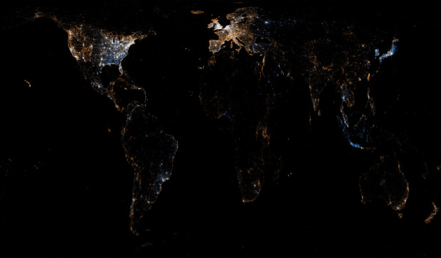
For all the maps by Eric Fischer I’ve posted, it’s amazing how little I actually know about him, but in his most recent series, See Something or Say Something, he places geocoded tweets and Flickr photos on the same map. Blue dots represent tweets with location and orange dots are Flickr photos. White dots are locations with both.
Here’s a zoomed in view of Europe:

And North America:

Not surprisingly, you see a lot of white dots at city centers. That’s an artifact of population density and Flickr and Twitter users. What’s more interesting though are the areas outside of the city dominated by blue and orange. For example, in the North America map above, the east is dominated by blue, whereas the west seems to be more orange.
What compels people to tweet over taking a picture and vice versa? Or are we just seeing a Twitter scrape that happened in the early morning, before the west coast woke up?
Although, photo-heavy places just might be places that have things that are, well, worth taking pictures of. This map of Manhattan, for example, follows a similar pattern to Fischer’s previous map on where tourists flock.

Here’s one more for Bangkok. Clear split between tweets and photos. I like how it’s fine grained enough we start to see roads.

See the full set of beautiful maps on Flickr.
Oh, and in case you’re wondering how Fischer made these maps, here’s how he did it:
There’s not a whole lot of technology behind it. It’s a C program that runs through the photos/tweets in chronological order, plotting the earliest ones the most brightly and stepping the brightness down for points that don’t show up for the first time until later on. Points are also allowed to diffuse by a few pixels when there is an additional record for a point that is already plotted, with the brightness falling off exponentially as the point that is actually plotted gets further from its intended location. Each pixel is the somewhat weird area of 2.25 square miles because a smaller area made the whole-world image too big for Flickr to let me post it.
Simple idea. Good execution. Pretty results.

 Visualize This: The FlowingData Guide to Design, Visualization, and Statistics (2nd Edition)
Nice one.
In Europe, you can clearly see the intensity of Orange in the Swiss Alps and the Pyrenees. Skiing vacations?
Beautiful maps. Three observations:
1) Appalachia and Rockies limiting tweeting (poor cell service?).
2) Cuba – no tweeting.
3) Coastal areas that are more “vacation” or relaxing spots than metropolis’s of business seem to suggest that people put down the mobile device (stop tweeting) and pick up the camera (start photographing). i.e. Coastal Mexico, Caribbean islands, South of France and NYC Central Park.
Both fascinating and gorgeous!
The map that you’ve listed as the “United States” is listed in Flickr as being “North America”, and a note that it’s going to be replaced with a different version. Perhaps that one will show all of North America.
Hint: the United States is one of only 3 countries in North America.
Try again. There are 23 countries in N. America.
Re: hypotheses about tweets vs. pics?
Here’s a simple theory: Tweets scale with population & “modernization”, pics scale with tourism and less so with “modernization”.
Lot’s of pretty little islands getting photographed in the “whole world” image…
Yes! But — next steps?
1 Debate: complexify, simplify, refine, reword, or ?
population, tourism, modernization >
urbanity, humanity
2 Model them, first as continua:
urbanexurban
naturebuilt
3 Then matrix them opposite each other
4 Exemplify–where do these go? urban parks, theme parks, islands=destinations, resorts; tricky: skyscrapers
5 Add Twitter and Flickr atop model; tricky part
6 See if/how data fit model, e g., a large scale/small area look at pretty islands (can data accommodate required granularity?)
http://k.homes.mcad.edu/~kbyrne/archive/model.jpg
The Netherlands is shining very bright, not only the cities.