
Evolving path of the Mississippi River
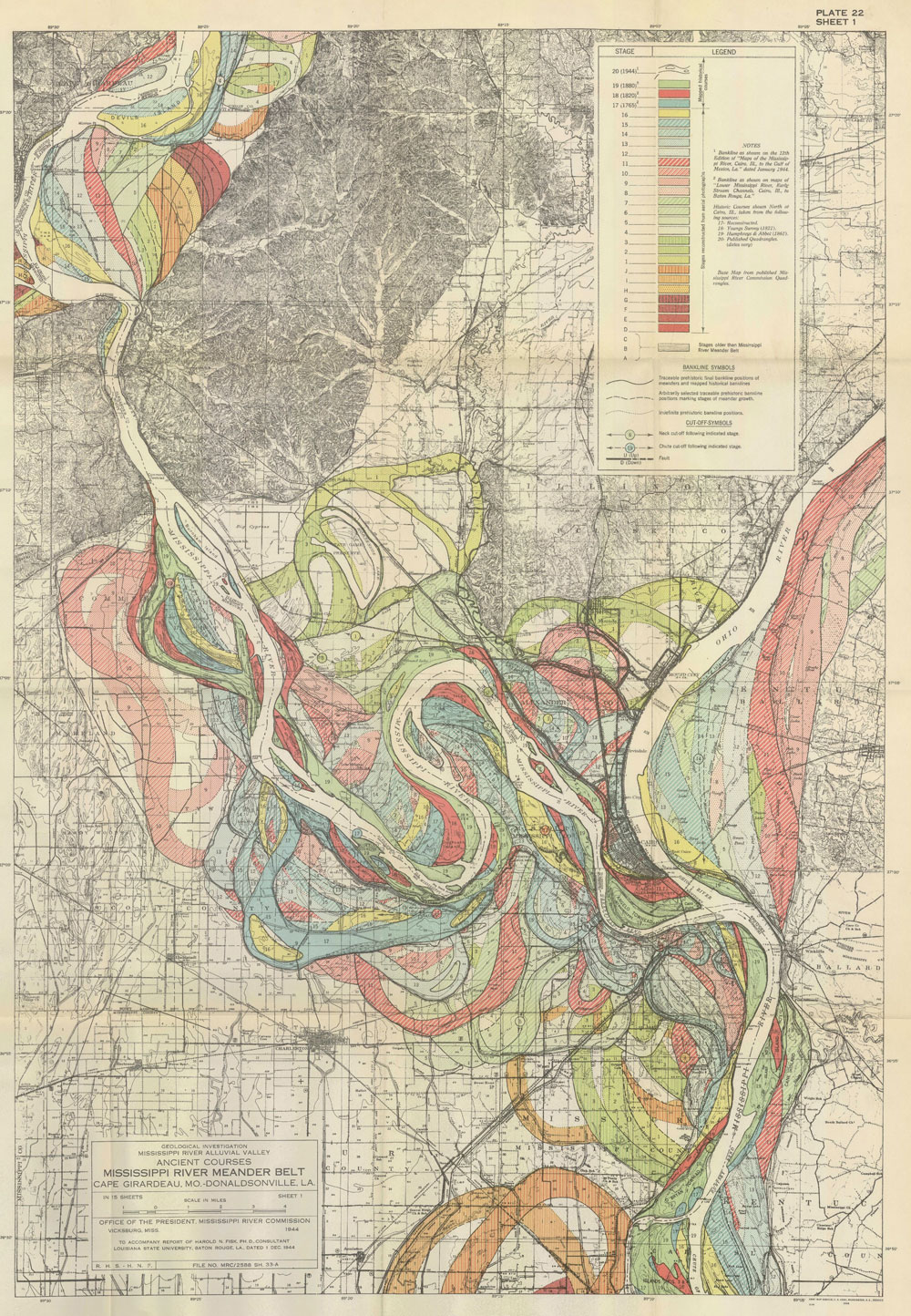
We often think of rivers as following a given path for the course of its life, but really, the path changes over time as the flow cuts into the earth. The water flows through old and new and back again. In 1944, cartographer Harold Fisk mapped the current Mississippi River. It’s the white trail. Then Fisk used old geological maps to display old paths. They’re the old colored paths. And what you get is this long run of windy, snake-like things. [Twisted History | Thanks, Michael]
10 Comments
Become a member. Support an independent site. Get extra visualization goodness.
See What You Get



Great map. All things change.
Ha. Flowing data. Geddit?
Make sure you click into the source site. The individual map pages connected to show the whole river was a real pleasant surprise.
There’s just something special about knowing a person made this incredible data-rich series with pen and ink (and other printing processes along the way). Every survey section line, French long lot boundary, road way, contour line and label was seemingly added with care.
“We often think of rivers as following a given path for the course of its life” – if that is the case I really do worry about designers’ ability to conceptual what hey visualise. Time and time again we see infographics poorly conceived an executed because the author doesn’t understand the phenomenon (and frequently the data) they are working on. Designers need to learn more about the methodologies used to capture, process and analyse the data they work with.
Love the map. Back in my early days as a geologist, I learned you never really learn the landscape until you make the map yourself, by hand. The topic reminds me of one of my favorite books: The Control of Nature, by John McPhee. The first section is titled Atchafalaya and covers some of the history and fluvial dynamics that shape the Mississippi River, written in a charming and accessible style.
Does anyone know where you can buy reproductions of these Fisk maps… they are so beautiful. I want to hang them on my walls.
The old meanders are visible in satellite data, too:
http://earthobservatory.nasa.gov/IOTD/view.php?id=6887
You can download high-res TIFFs of the maps here:
http://lmvmapping.erdc.usace.army.mil/index.htm
Just wonderful. I used Fisk’s work as a reference to the old paths and new paths that are found in the investment markets.
Pingback: Geology Links for September 27th, 2010 | The Geology News Blog