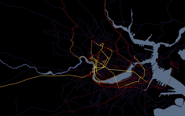
Cartographer Andy Woodruff documents all the places he goes, resulting in the pretty map above.
I have collected all my travels within the immediate local area (Boston) into a series of maps categorized by the mode of transportation for each trip. These are not GPS tracks; I remain low-tech and manually record each trip on a map. Any given segment has a line drawn once per day per mode of transportation.
The above map is all of Woodruff’s travels for 2010, but he also has the breakdowns by mode of transportation. Here are the maps for bicycle and train, for example:

That’s some serious dedication, and an obvious love for what he does. My favorite is the map journal he keeps to document the counties he has visited in his life. Red shows the 2010 gains.

I can’t even remember the states I’ve visited, but seeing this makes me feel like I should pay more attention, if just for the sake of not forgetting things.
[Cartogrammer via @awoodruff]
 Visualize This: The FlowingData Guide to Design, Visualization, and Statistics (2nd Edition)
Ha, thanks for sharing, Nathan!
Fabian Neuhaus of UrbanTick has a nice roundup of some awesome annual GPS summaries: those of Eric Fischer, Achim Tack, and himself.
County collecting, meanwhile, is a true geek sport! Here’s a decent site for keeping track: http://counties.visitedmap.com. Some day my county rival Robert Roth (@rothzilla) and I are going to fulfill our destinies and build a ridiculous, amazing mapping tool for county collecting.
Hehe, looking forward to it. In the meantime, visitedmap it is.
I am going to do some travelliing for six months next year across Africa and am looking for a GPS datalogger with long battery life that I can stitch into a backpack and leave there? Any ideas?
M
Nathan, this is great! I did something similar for the year that my wife and I backpacked in South America; I blogged about our travels and mapped each place we stopped in, giving a pretty cool map of our travel (that you can stop at any point and read the stories/see the pictures from). If you’re interested, check it out: http://www.stefandmatt.com/where-weve-been/
Pingback: Do I Want To Change The Story? « It Just Dawned On Me