Grocery store geography

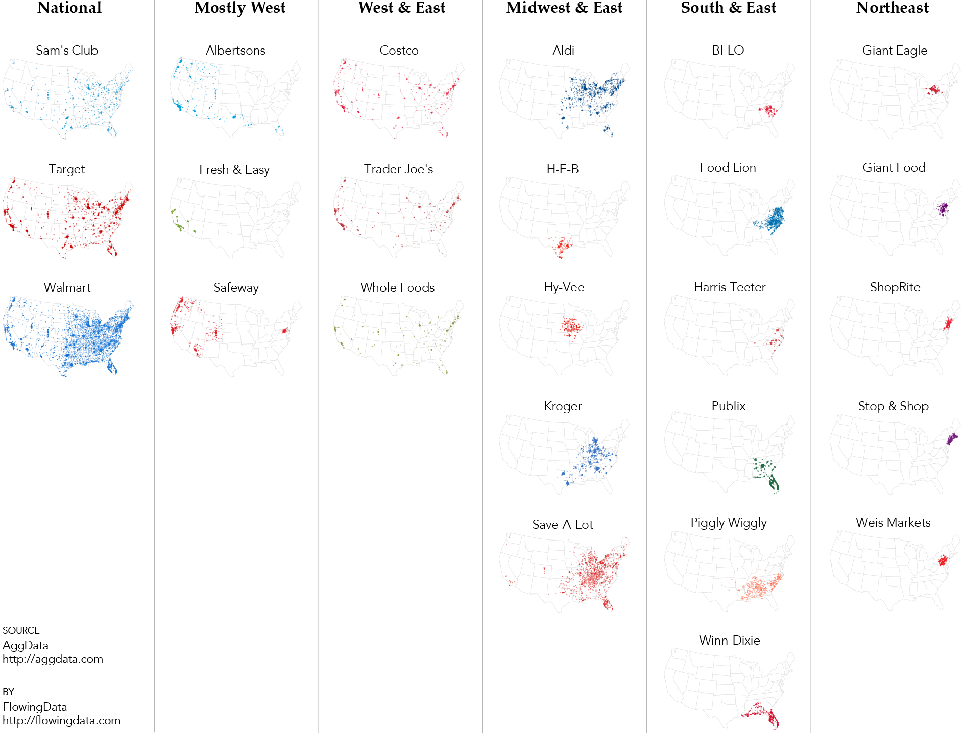
I’ve been poking around grocery store locations, courtesy of AggData, the past few days.
There’s a grocery store just about everywhere you go in the United States, because, well, we gotta eat. They look similar in that they sell produce on one side, meat in the back, and snacks and soda on the side opposite the produce. Magazines and small candies are carefully situated at eye-level by the cash registers. There’s usually a deli counter and prepared foods near the bread section. And yet, despite the generic format and layout, these stores can remind us of places and specific periods of our lives.
When I was a kid, I’d go to Save Mart and you’d get hit with the aroma of cupcakes and fresh bread from the bakery right at the entrance. They had cake samples at the counter, which was too high for me to reach, so my mom would grab me a piece. I totally get the “like a fat kid loves cake” line.
In college, I went to Safeway, and they had this magical barrier around the parking lot that prevented carts from rolling away and to deter people from stealing them. There always seemed to be homeless guy grasping a bottle held in a paper bag. It was probably milk. Two 12-packs of soda for five bucks? Yes, please.
When I was in Buffalo, I went to Wegmans. Somehow it was busy almost any time I went but the lines were almost always short. They had good, inexpensive grapefruit juice.
Then there’s the Targets and Walmarts, which are ubiquitous and seem to remind you of everywhere and nowhere at the same time.
It’s fun to poke around at these memories. What do your grocery stores remind you of?
The maps above show grocery stores with at least two hundred locations in the United States. I used a dissimilarity index and k-means for categorization, which popped out geographic distributions more or less. More to come.
 Small Maps and Grids
See hot to make small multiples with maps in R.
Become a member. Support an independent site. Get extra visualization goodness.
See What You Get


Where’s Publix?!
Added.
Randalls in Texas is Safeway owned; as I’m sure others are in other locations.
Dominic’s in the Chicagoland area is owned by Safeway also.
No Wegmans?
These maps only show stores with at least 200 locations.
Might be telling to also note or graph relationships among these supermarkets (e.g., Walmart Stores, Inc. owns Sam’s Club and Walmart; Ahold USA owns Stop & Shop and Giant; Aldi and Trader Joe’s stores in the U.S. are operated by the German Aldi group; etc.).
Wrong on Aldi and Trader Joe’s. There is a family ownership link, but no operational link unless things have changed drastically recently.
This is awesome. But why is the column clearly depicting Southern chains labeled East?
The Piggly Wiggly information is sort of incorrect. Wisconsin is filled with Piggly Wigglys.
What about Publix? That was my first job!
The “West and East” category is misnamed. If you look at the Walmart vs Target distribution, you will see that Walmart is much smoother — there is a Walmart in every county while Target is only found in more urbanised areas. The West and East category is really just the more urbanised centers. There are Whole Foods in major Midwestern and Southern cities: Chicago, Atlanta, Detroid, Cleveland, Dallas. But there aren’t any at all in Upstate New York, despite being a highly urbanised Eastern area. We’re really seeing the difference between alpha cities like Chicago and beta cities like Albany.
I see that there are regional chains in the Northeast and East, but I know that there are similar midwestern chains of equivalent concentration, for example Michigan-based Meijers (with stores in adjacent parts of neighboring states) http://image.mapmuse.com/images/maps/map-of-meijer-locations.png . I wonder what kept these out of the analysis.
He said he used stores with >200 locations.
I noticed the absence of Publix too. Also A&P would be an interesting case – currently it has over 300 locations. However, in the 1930s they had over 16,000 locations, so a map over time would be great. I know that data is not available on AggData….
Do you have any idea of making this graphs but using the distance to any of these stores against income percentile for the area?
Food deserts come to mind.
this
What about Hy-Vee? Your Upper Midwest isn’t represented.
I was about to say the same.
Where’s Wegmans? They are all over the Northeast, an institution:
Wegmans operates 81 stores: 46 in New York State, 15 in Pennsylvania, 7 in New Jersey, 6 in Virginia, 6 in Maryland and 1 in Massachusetts.
Wegmans employs over 44,000 people.
In 2012, Wegmans received more than 5,200 requests from people asking the company to open a store in their community. Another 7,600 customers wrote to say how much they like shopping at Wegmans, because they like the products and services offered or appreciate the way Wegmans employees treat them.
“There’s a grocery store just about everywhere you go in the United States, because, well, we gotta eat.” This very premise is wrong and smacks of privilege. I challenge you to spend some time looking up “food deserts”, areas where there are no supermarkets, and the resulting effects on poverty, urban blight, and violence.
I think your geographic groupings miss the phenomenon of “Southern” stores (Piggly Wiggly, Winn-Dixie, etc.).
And if your fav store isn’t on here, NY said he only took stores with >200 locations.
Fantastic visualization. As an ex-CPG marketer, I really appreciate seeing in one place where all the stores are located by chain. This kind of model would work well for anyone trying to show retail locations or product distribution. Thanks.
Ralph’s & Smith’s are Kroger’s. So, it actually becomes national?
As is Fred Meyer and QFC, here in the Pacific NW. Kroger is genuinely national.
Nathan, can you (or anyone else) explain what you used the clustering for? I assumed this was just a plot of the locations of each store.
@Nate — You’re right, the locations are placed directly on the map based on latitude and longitude. The dissimilarity and k-means was to cluster the stores, which ended up being regional categories like you see in the graphic.
I was hoping for something more subtle, like stores that tend to locate in wealthier counties and those that location in poorer counties. But the metrics I used weren’t granular enough to see that. Maybe in the next go around.
I’m sad, my favorite stores are Fred Meyer and QFC (both owned by Kroger), but with store counts of 130 and 75 respectively, neither made the list :-(
Like any data of this nature, it does seem biased to the more denser regions of the country. I wonder what it would look like with a variable threshold based on the population of the states, region, etc.
Neat maps. A few comments:
– Walmart is not in every county. Numerous counties across the country where Walmart isn’t in place.
– Agree with other commenters about WinnDixie and Piggly Wiggly being predominantly “Southeastern” institutions.
– Would like to see similar maps going with a store frequency >= 100 vice 200. As a few others noted, there are SEVERAL Upper Midwestern and New England chains missing.
Publix has almost twice the amount of stores that BILO or Winn Dixie does and owns the state of Florida, with strength throughout the Southeast…. how would they not be on this map?? I think there are some major inaccuracies here.
What about Hy-Vee? That’s where I went when I lived in Minnesota and Missouri.
Added.
There’s something that doesn’t look quite right here. There are a few Piggly Wigglys I’m aware of in Wisconsin, but not a single dot.
As others have pointed out, this data is kinda funky. Publix is centered in South Florida, and most of its stores are in Florida…
But the map doesn’t reflect this at all.
Also, the maps for Piggly Wiggly and Publix are identical, except for color.
I think I’ll avoid using AggData in the future… it seems to be rubbish.
I goofed in my code. Publix fixed. I think Piggly Wiggly is a little weird in the data, because the Piggly Wiggly site separates stores in Wisconsin and Illinois from all other locations.
Smith’s is pretty dominant in the Rocky Mountain/Four Corners states. They are part of Kroger.
You also missed a bunch of Albertson’s, hundreds of locations east of Nevada and California.
Check out the thread on Reddit discussing your graphic, there are a lot more comments pointing to missing data to fill out the map.
http://www.reddit.com/r/dataisbeautiful/comments/1howmx/grocery_store_geography/
Thanks, Rey. The post pointed directly to the image instead of this post so I didn’t see the Reddit comments until now. I addressed some of the comments.
One major omission…IGA. Although all IGA’s are independently owned, there are still at least 4000 or so stores nationwide operating under the IGA banner.
Also, if you include ALL banners operated by Kroger and Safeway, instead of just their namesake stores, there will be more nationwide presence.
Hey Kroger just purchased Harris Teeter:
http://online.wsj.com/article/SB10001424127887323368704578595310330531012.html
The maps above only show locations who match the stores’ names. So Kroger locations shown in the graphic are only locations that are actually named Kroger. I’m gonna take a look at the hierarchy of stores in the next go around.
Supervalu brand stores, besides Save-A-Lot? Minnesota is blanketed by them.
“dissimilarity index and k-means for categorization”? At this scale, these appear to just be dot maps. Can you elaborate?
Pathmark? I guess maybe they don’t have at least 200 stores?
Where is Meijer? They have >200 locations.
What I learned from this post-the commenters on your site are assholes.
Where are AK and HI?
Interesting maps! Vons is a big chain in the west with over 300 stores, but is owned by Safeway. In the Safeway map, the Vons stores would fill southern CA, but it might also be a good map by itself.
There are in fact 2 different Giant Food’s. One based in Landover Maryland and the other in Carlise Pennsylvania