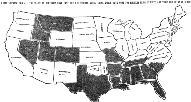
Matthew Ericson, deputy graphics director of The New York Times, dug through the archives to find the first occurrence of an election map in the paper, in 1896:
The speed with which the results made it into print boggles the mind given the technology of the day (especially considering that in the last few elections in the 2000s, with all of the technology available to us, there have been a number of states that we haven’t been able to call in the Wednesday paper).
What a beaut. That day, the paper cost 3 cents.
 Visualize This: The FlowingData Guide to Design, Visualization, and Statistics (2nd Edition)
For a good sense of this time period and the ability to rapidly send/receive information, I highly recommend the book The Victorian Internet by Tom Standage ( ISBN-10: 0802716040
ISBN-13: 978-0802716040 ). You might be surprised at the capabilities of “way back when”.
Thanks, Tony. Adding this to my wishlist.
Nice post showing the ideas on data visualization did not change that much in 100 years, only the tools did!
Very nice blog you’ve got going, Nathan.
The funny thing is that, even after adjusting those three cents to current dollars (http://www.minneapolisfed.org/community_education/teacher/calc/hist1800.cfm), The NYT was cheaper back then: $0.79 in 1896, compared with $1.06 (with a 50% off subscription!) today. We’re not controlling for quality, but still.
Ahh. The good old days, when blue and red states were gray and white states.