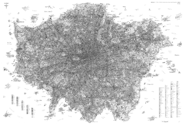
Stephen Walter’s The Island looks like an ordinary map of London from afar. Just a bunch of scribbles, actually. But zoom in and you get something more.
The Island satirises the London-centric view of the English capital and its commuter towns as independent from the rest of the country. The artist, a Londoner with a love of his native city, offers up a huge range of local and personal information in words and symbols. Walter speaks in the dialect of today, focusing on what he deems interesting or mundane.
Zoom in once. Outlines and locations appear.

Zoom in all the way. It’s an extremely local and personal view of the area. You see tiny narratives, little icons, and and scribbled roads.

I’ve personally never been, so the meaning is kind of lost on me. I am however very interested in this flower show in Chelsea. Any locals care to comment on the accuracy of this thing?
[via @creativeapps]
 Visualize This: The FlowingData Guide to Design, Visualization, and Statistics (2nd Edition)
yeah, this is really accurate from the parts of london I know well, i even learnt some new things about the area in which I live in from it :)
I saw this in real life at the british library, it was amazing to look over.
well, it’s fairly accurate if you ignore the imaginary coastline :)
How did they miss Shakespeare’s Globe theatre? It’s just to the east of the Tate Modern, in the Borough (center of the city, on the south bank). Despite this omission, they found space for SE1 Club (nearby, by city hall). That club is cool and all, but I wouldn’t list it above the Globe (especially because of the 10 quid cover).
I do like the tourist warning by Trafalgar though.
I may buy a copy for my wall. It’s something you could stare at for hours.
There is indeed a (very famous) flower show in Chelsea:
http://www.rhs.org.uk/Shows-Events/RHS-Chelsea-Flower-Show/2010
Apparently 2010 was a vintage year.
Was included in this BBC show – The Beauty of Maps
http://www.bbc.co.uk/bbcfour/beautyofmaps/index.shtml
Great and informative viewing if you can make the time.
Actually, this deserves a place in the Magnificent Maps exhibition at the British Library:
http://www.bl.uk/magnificentmaps/
Oh, it *is* at the British Library. That’ll teach me to not click the link before I comment. Duh.
Yes, it’s pretty accurate…went to see it on Sunday. It was pretty amazing close up. People were gathered around it for ages pointing out amusing parts and looking at the areas they were familiar with. Could have looked at it for hours and still found something new to laugh at!
Pingback: Uber detailed London map satire / what consumes me, bud caddell
This map was created as a piece of art, a very personal representation of London. Which is why some landmarks are missed off.
Check out the artists own web site: http://www.stephenwalter.co.uk/home.php
Pingback: Uber detailed London map satire | Artist News
Pingback: Uber detailed London map satire | SingleMeasures
Yes Chelsea has a flower show. http://www.telegraph.co.uk/gardening/chelseaflowershow/5349670/James-Mays-Plasticine-garden-wins-special-award-at-Chelsea-Flower-Show-2009.html Now we need some TopGear Infographics.
I saw it at the BL exhibition a week or so ago, and thought it was awesome. I wrote to the artist asking whether prints were available. I had a reply from a gallery saying that yes, they did have a few of the limited edition remaining, they were £10,000 each… ;-)
thanks for the input, everyone. now i’m wishing someone would do similar maps for wherever i go. Could be good for a whole line of tourist maps.
Pingback: Data Life of the Future [W/Video]