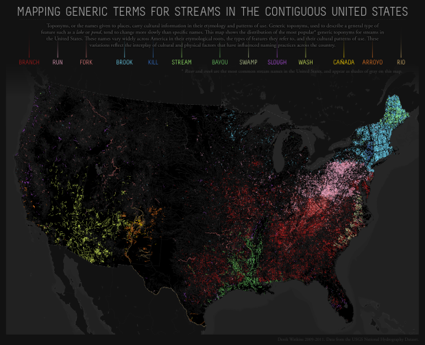
The names of places can say a lot about a geographic area. Derek Watkins maps the most common term for a stream across the country. You’ve got branches and bayous in the south, brooks and streams in the northeast, and washes and arroyos in the southwest.
Some historical context from Watkins:
Lite-Brite aesthetic notwithstanding, I like this map because it illustrates the range of cultural and environmental factors that affect how we label and interact with the world. Lime green bayous follow historical French settlement patterns along the Gulf Coast and up Louisiana streams. The distribution of the Dutch-derived term kill (dark blue) in New York echoes the colonial settlement of “New Netherland” (as well as furnishing half of a specific toponym to the Catskill Mountains). Similarly, the spanish-derived terms rio, arroyo, and cañada (orange hues) trace the early advances of conquistadors into present-day northern New Mexico, an area that still retains some unique cultural traits. Washes in the southwest reflect the intermittent rainfall of the region, while streams named swamps (desaturated green) along the Atlantic seaboard highlight where the coastal plain meets the Appalachian Piedmont at the fall line.
 Visualize This: The FlowingData Guide to Design, Visualization, and Statistics (2nd Edition)
I guess that if you liked Watkins’ map, you’ll lile Mapr too, which does pretty the same, but automatically.
Check, for instance, this example
http://www.pimpampum.net/labs/mapr/?tags=playa,beach,plage,platja,praia,&clat=31.3&clng=-12.53&dlat=10.69&dlng=26.74&zoom=0.5&lang=en
with the geolocalisation in Flickr of phots tagged with playa, beach, plage, platja and praia.
Best,
i.
That is absolutely fantastic! Thanks for the link Ismael. I’ve been doing research lately dealing with geotagged flickr photos, so this is awesome.
thanks!!! you can check other examples here
(sorry but the post is in spanish) but you can click
on the images to look at the real samples
http://www.kiwoo.org/blog/2011/01/06/mapr-visualiza-mapas-generados-por-las-posicion-de-las-fotos-en-flickr/
enjoy!
What about creek, especially creek pronounced ‘crick’? Is that too common/uncommon to make the map?
according to the longer explanation at the link, creeks and rivers are shown in grey because they’re way more common than the other names.
This could be fun with mountains names. In the alps every valley tends to name their peaks in a different way: Spitze, Kogel, Halt, Kofel, Stein, Spitze, Horn… to name just a few.
um… that’s the southwest with all of the washes and arroyos.
Thanks
Why is there a blank strip from West Texas up to the Dakotas? There have to be as many streams in this region as in Arizona which shows up brightly.
Neat!
The graphic interface is not as pretty, but the data are very rich at the Harvard Dialect Survey site:
http://www4.uwm.edu/FLL/linguistics/dialect/maps.html
If you want an interactive North American dialect map go to: http://aschmann.net/AmEng/