ITO world, who you might remember from a year of OpenStreetMap edits, come back to the map visualization to show the efforts of an impromptu community and Crisis Mappers to produce the most complete and accurate map of Haiti following the earthquake.
From the ITO blog:
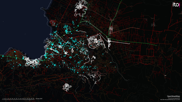
Each flash represents a new edit into OpenStreetMap, and this visualisation is a vivid picture of how much work was contributed by volunteers, following the quake. First the primary and secondary roads (green and red) are added and then smaller residential streets and many other features such as the blue glowing camps of displaced people that emerge.
Watch the mapping frenzy unfold below.
[Thanks, Christopher]
 Visualize This: The FlowingData Guide to Design, Visualization, and Statistics (2nd Edition)
Pingback: Intrinsic motivation with a live crowdsourcing video helping Haiti via maps | Designing Better Futures
Pingback: OpenStreetMap and Haiti Relief « Visual Security
Pingback: Coase’s Penguin, ReCAPTCHA and OpenStreetMap in Haiti « TK in TX