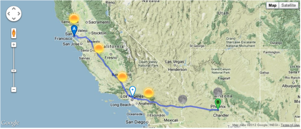
Online maps have made it easy to find directions from point A to point B, but when you’re going on a long road trip, you want to know more about where you’re going. What will the weather be like? What is there to do at each stopped? Design and technology studio Stamen made a travel planner in work for the Weather Channel that tells you. Put in your origin and destination and when you will leave, and you get a map with weather icons along the way.
So let’s say you’re driving from New York to San Francisco, and you’re trying to decide whether to go straight across or loop up or down a bit; this will give you a sense for whether it’s going to be rainy or sunny when you plan to be in the middle of Nebraska. You can drag around the rainy bits if you like, and also along the way maybe you’d like to stop for a bite to eat, so we’re hitting the Yelp API to give you a sense of where to go and what to see.
Give it a try here. It’s kind of awesome.


At one point I contemplated designing something like this for boats transiting remote waters in Alaska. It’s a risky business, and the weather analysis is complex. Alaska fishermen (and women) tend to be motivated to read weather forecasts with great sophistication.
So imagine an interactive map (really a model) where you enter your start point, end point, the speed characteristics of your boat, and what you consider allowable parameters for the safe passage of your boat (e.g. a maximum wave height). The model sends a virtual boat on the transit, and identifies whether at any point the boat would pass through conditions that exceeded the specs. Ideally the weather predictions are probabilistic so you get a result like, “There’s a 35% chance that conditions would be unsafe at some point on your trip.” Also it’d be great to visualize the map in a way similar to this example.
One problem is that the results would have a high probability of being flawed, and in the event of a boating accident the maintainer of the model might be vulnerable to a lawsuit.
But broadly speaking, the idea of overlaying temporal data on a planned route is pretty neat.
I’m a fulltime RVer so I’m always interested in trip planners. This was of no use. There’s only one route option (unless I can’t figure out how to use it) and it’s the interstate (ugh). Not only that, it assumed I would cover 2600 miles in two days — I’m sorry but I don’t drive on uppers any more.
I agree with @Lindig. It really needs to at least have the option for driving hours per day.