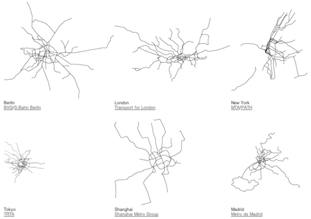
Urban planner Neil Freeman maps the world’s subway systems to scale in a minimal style resembling the scribbles or renderings of weird sea creatures by a two-year-old. I wish there were nodes to show stops, too, but the contrasts between the compact TRTA in Tokyo and RATP in Paris, and the spread out Seoul Metro and Transport for London is an interesting look.
[Neil Freeman via @kennethfield]
 Visualize This: The FlowingData Guide to Design, Visualization, and Statistics (2nd Edition)
It feels like there’s a loose definition of “Subway”. From what I remember – BART isn’t much of a subway. And would be more the equivalent of say the RER trains in Paris. Makes comparisons like this pretty hard.
I was about to make the exact same point. But it is still a nice work ;-)
I was about to make the exact same point (with the same examples).
But it is still a nice work ;-)
He forgot the Cincinnati Subway:
http://en.wikipedia.org/wiki/Cincinnati_Subway
Oh wait, never mind…
no Warsaw?!?!
Amsterdam metro covers the same area as Tokyo? Really??
The issue with Tokyo is that the metropolitan subway is only one of the companies which offers a service for commuting in Tokyo Area. There are a lot of companies mixing things which are sometimes train or subway (underneath the surface) for the same line.
It also depends on what you count as the limits of the city. Tokyo city itself doesn’t really exist. Tokyo 23 is the assembly of a few districts and Tokyo Prefecture is reaching a lot of people.
Then there is the social dimension of this kind of drawing. Japanese commutes a lot by train, subway with 2 hours (one way) of commuting being common. So you may address the surface considering the population commuting in an area.
Basically it is a complex issue to render.
It is probably an indication of the level of infrastructure support that a country/city is prepared to invest in. One further comparison might be total urban (city) track miles in each country.