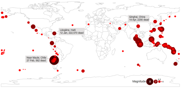
Haiti’s earthquake in 2010 was by far the most devastating in a long time. There were an estimated 222,570 casualties as a result. However, as Peter Aldhous shows in this graphic, the Haiti quake was not the most powerful.
The earthquake that struck near the Haitian capital, Port-au-Prince, on 12 January 2010, was unremarkable in seismic terms — barely making the year’s top 20 most powerful quakes. But it was one of the most deadly seismic events in the past four decades, serving as a reminder that the scope of these disasters is defined not by the scale of the Earth’s unleashed fury, but by overcrowding in poor urban areas and lax or poorly enforced building codes.
In a few decades from now, someone could easily make the mistake of graphing out seismic data for 2010 and pointing out only the biggest one. But then they’d be missing the quake that should have the most emphasis.
The same goes for your own data. You’re going to miss a lot when all you’re looking at is one column.
[Earthquakes | Thanks, Peter]
 Visualize This: The FlowingData Guide to Design, Visualization, and Statistics (2nd Edition)
It tells how well-prepared Chile was for this earthquake.