In a different look to the let’s-map-geotagged-photos idea, photographer Eric Fischer maps picture locations of major cities in the world.
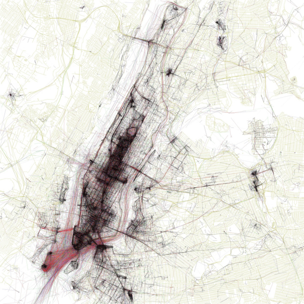
The maps are ordered by the number of pictures taken in the central cluster of each one. This is a little unfair to aggressively polycentric cities like Tokyo and Los Angeles, which probably get lower placement than they really deserve because there are gaps where no one took any pictures. The central cluster of each map is not necessarily in the center of each image, because the image bounds are chosen to include as many geotagged locations as possible near the central cluster. All the maps are to the same scale, chosen to be just large enough for the central New York cluster to fit.
Additionally, trace color indicates mode of transportation. Black is walking, red is bicycling, and blue is moving by motor vehicle. From what I gather, photos either come straight from Flickr or a teamed group of people. Unfortunately, that’s all I can find though. Some more explanation would probably make these a lot more enjoyable. Nevertheless, they’re nice to look at.
Major streets emerge, bridges with bicycle lanes appear, and they’ve got a sexy spider web thing going for them.
Here are the maps for London and San Francisco, respectively.


Check out Fischer’s full set on Flickr.
Update: Fischer comments, “I got the photo locations from the Flickr and Picasa search APIs. The base maps that they are plotted on top of are from OpenStreetMap. I wrote some perl scripts to identify and plot the clusters of locations. The scripts generate PostScript which I then converted to JPEGs using Ghostscript.”
 Visualize This: The FlowingData Guide to Design, Visualization, and Statistics (2nd Edition)
Pingback: Cities mapped by photo density | P Morgan Brown
There is a bit of explanation here:
http://burritojustice.com/2010/05/19/look-upon-my-geotagged-map-ye-mighty-and-despair/
Basically you query the api for pairs of photos taken in a short interval (10 mins). Then you take the distance between them divided by the time between shots, that is your velocity. The black is walking speed, the green is driving, etc.
Pingback: Layout | Geotagger Maps « Layman's layout
Pingback: World atlas of Flickr geotaggers is maptastic « Means Justifying Ends
Pingback: At&t High Speed Internet Connection Speed | Cheap Broadband Internet
Gorgeous work!
Pingback: Infographic of the Day: Using Flickr Geotags to Map the World’s Cities | Web Design Cool
Pingback: Infographic of the Day: Using Flickr Geotags to Map the World’s Cities | Gabbur
Pingback: Infographic of the Day: Using Flickr Geotags to Map the World’s Cities
Pingback: Other Ten Percent » Blog Archive » Other Ten Percent 5/27/10
Pingback: Visual delight #10 / Tactile « Visual delights
Pingback: Whataplan.com » Blog Archive » Mapping London – The Geotaggers’ approach
Pingback: Pants Olive | Paintball Buy and Sell
Pingback: #10 / tactile « Visual delights
Pingback: adaptive path » blog » Adaptive Path » Signposts for the week ending June 4, 2010
Pingback: The Geotaggers World Atlas | Visual & Visible
Pingback: Infographic of the Day: Using Flickr Geotags to Map the World’s Cities [UPDATED] | Web Design Cool
Pingback: Infographic of the Day: Using Flickr Geotags to Map the World’s Cities [UPDATED]