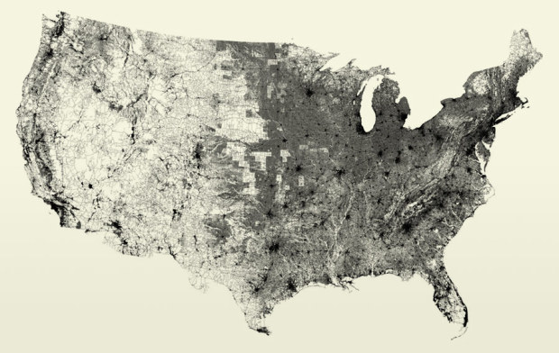
Ben Fry maps every road segment in All Streets, according to the U.S. Census Bureau’s TIGER/Line data. There’s no actual map or drawn borders; instead Ben chooses to let the data do all the work, and the results are very pretty. Sometimes you don’t need a map to map.
I was somewhat surprised to see California’s low road density compared to the eastern half of the country, but I guess that’s because of all the freeways. What’s more surprising though is that line down the middle. Roads all of a sudden go dense somewhere around North Dakota. Is that really what it’s like? Does farming suddenly stop and urban life begins in these areas?
Poor Alaska and Hawaii, with too few roads, were left out.
 Visualize This: The FlowingData Guide to Design, Visualization, and Statistics (2nd Edition)
It would be neat to see this displayed as a google map so that you could zoom around a bit more freely.
As a farmer from North Dakota, my guess is that what you’re seeing is actually the exact opposite: farmland in my state is divided into “sections,” which are 1 x 1 mile squares of 640 acres, and “quarters.” There’s almost always a road at each section, and sometimes roads that bisect the section into quarters. This ensured access to each farmer’s field back in the days when homesteaders only had a quarter or two of land. Now, farms are much bigger, but most of the roads remain.
Wow! That’s interesting. It looks like I-5 in California gave rise to sprawl (or at least roads).
If you look at a topographical map, it appears that this observed line is consistent with an increase in elevation. Launch something like MS Map Point, view the US as a Terrain Map, and the picture is strikingly similar to the one above.
Makes sense that foothills and mountains make for fewer roads.
@aleska: i was hoping someone would pick up on that :)
“Roads all of a sudden go dense somewhere around North Dakota. Is that really what it’s like? Does farming suddenly stop and urban life begins in these areas?”
Actually, I think that’s slightly wrong: farming basically stops on the left side of the line, not on the right. West of that line, the land is comprised of open range. East of the line, there are still a number of predominantly rural states — Illinois, Indiana, Iowa, etc. — that have a dense character in the map. Like Gary mentioned in ND, we had the same section roads in Illinois, so the density of roads doesn’t match the population density.
As @aleska noted, the topography of the Rocky Mountains isn’t appropriate for crops. Farther west: deserts, more mountains, etc.
Absolutely beautiful and brilliant. Thanks for sharing these.
@Ryan – The dense area you see in central California is not along the I-5, but rather CA 99 – which parallels the railroad mainline and is home to some of the oldest cities in California. I-5 was built miles away from almost all of these population centers on purpose, since it’s primary goal was to connect LA and SF as quickly a possible.
@ikeM: nothing like some great context to add more meaning.